
Listen to the podcast by Prem Chandavarkar here.
The Government of India is proposing a radical reshaping of the architecture and landscape of New Delhi’s Central Vista: a precinct that is the geographical heart of India’s democracy containing Parliament, ministerial offices, the residence and office of the President of India, major cultural institutions, and a public landscape that is beloved to the residents of Delhi and citizens of India. Its design originally came into being in 1913-14 as a British creation meant to mark imperial power in India through a new capital city in Delhi. After Independence, its buildings and spaces have been appropriated by Indians.
How was the original design meant to serve as a public symbol of imperial power and governance? In the seven plus decades since Independence, how has it been appropriated by Indians such that during those decades it has become an integral part of the independent nation’s history, leading to the precinct and its major edifices receiving the highest listing of Grade-1 from the Heritage Conservation Committee, Delhi? And what light does the currently planned redevelopment throw on the direction that contemporary India’s governance is taking, especially in reference to its equation with the general public?
To understand these questions in their full depth, we must examine the history of how city form has visually reflected political ideals of governance.
Representation of Governance in Urban Design
Until the 14th century CE, depicting governance through urban design was a relatively straightforward challenge, for power flowed from a unitary source that was feudal and dominant. The city needed a single centre that depicted its governance, usually expressed in a monument from which power flowed, such as a fort, palace, church, temple or mosque. This monument would be sized at a scale that was far larger than its surroundings so that it was visually prominent. The consequent dominance of city form was an important factor given that power claimed its place more through force than persuasion. The typical city had a singular centre, often within a territory defined by fortified walls, that epitomised its socio-political order.
This urban design strategy began to unravel around the 15th century CE, when Europe began to dominate oceanic navigation and gunpowder technology, and thereby became a hegemonic world power. Technologies of travel made the world more connected, trade flourished, and a new breed of traders and businessmen emerged whose wealth, and its consequent influence, could compete with political rulers at a scale not seen before. Scientific investigation, as a source of knowledge, began to win public recognition leading to the development of specialists in knowledge, undermining an earlier era where the sanction of political authority determined which knowledge was to be considered worthy. The Catholic Church, which had been the dominant power in Europe, had its hegemony challenged by the Protestant Reformation. Power and knowledge were becoming diffused, democratic and secular, and urban design had to rise to the challenge of how to represent this.
[The] boulevard-centred trend led to a new element being deployed in urban design: the grand urban axis, a straight and wide boulevard focusing on key monuments at either end, lined with significant buildings, all coming together to make a strong symbolic statement in the centre of a city.
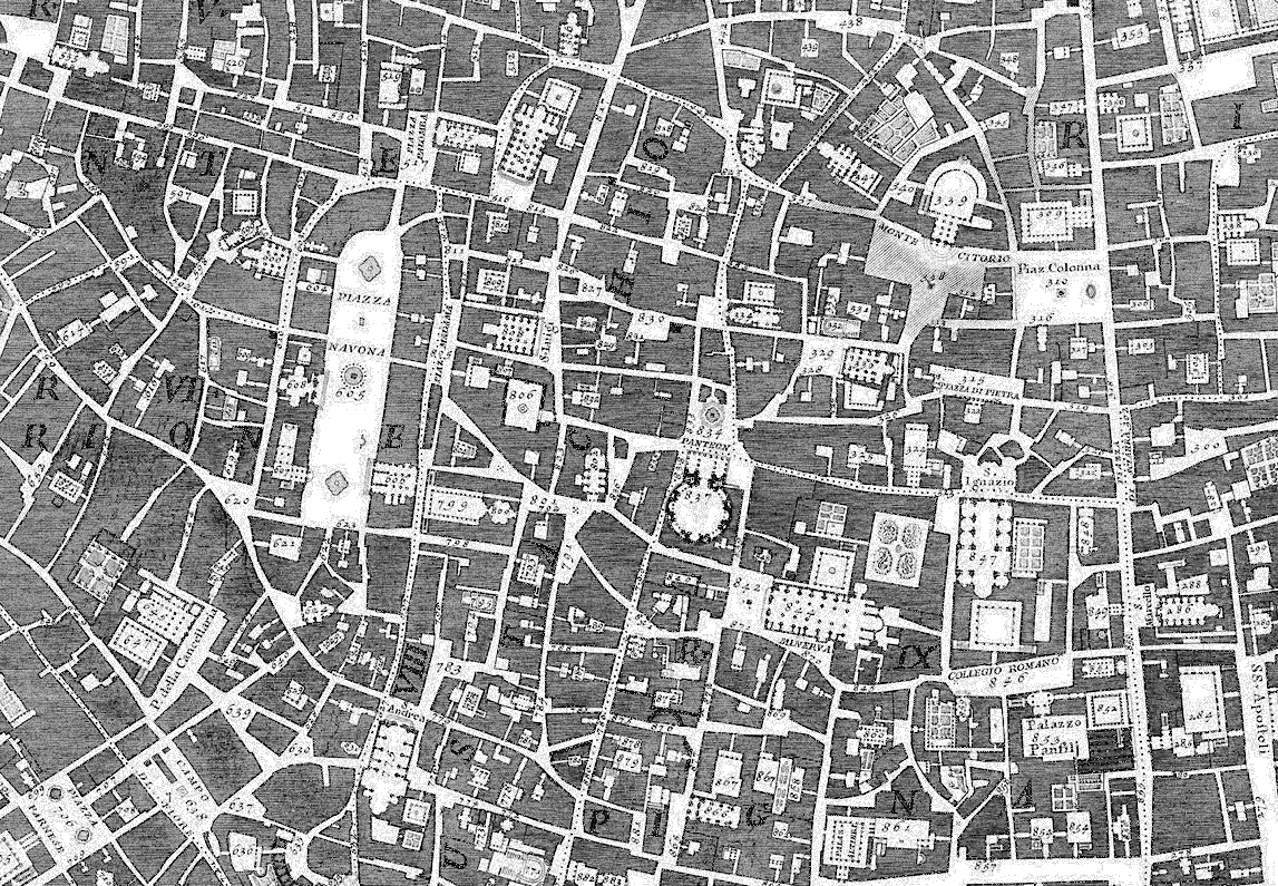
In 1748, an Italian cartographer called Giambattista Nolli produced a map of Rome (Illustration 1) that represented the idea of a multi-centred secular city with a clarity hitherto unseen. The private realm was drawn in figure-ground silhouette so that it sharply demarcated the legibility of streets, squares and other open-to-sky public spaces. Important public institutions were shown in full plan detail, delineating their interior spaces in a graphic technique that integrated them with the public realm. The Nolli Map established two key notions in urban design. First, it showed how the city could be comprehended through a visually coherent pattern of open public space shaped by the facades of its buildings. And second, it posited that the spatial distribution of public institutions within this coherence reflected the socio-political order of the city. This allowed the city to be perceived as a multi-centred and secular network, rather than a singular entity focused on a dominant centre. The Nolli Map is one of urban design’s most influential representations of modern city space, and its impact is felt till this day.
University of Oregon Nolli Map Copyright 2020. Reprinted by permission of the University of Oregon Nolli Map Project http://nolli.uoregon.edu
University of Oregon Nolli Map Copyright 2020. Reprinted by permission of the University of Oregon Nolli Map Project http://nolli.uoregon.edu
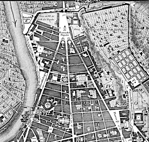
The notion that spatial positioning of institutions gives order to public space was not invented by Nolli; his contribution was to capture the clarity of the concept in maps. The idea had risen over a century earlier when the churn of the Protestant Reformation made it apparent that political power needed to reduce its dependence on force and rely more on persuasion. In response, urban design deployed a rhetorical strategy that heightened emphasis on institutions and public monuments by carving out roads or pathways that focused on them. Nolli’s plan captures a notable instance: The Piazza del Popolo (Illustration 2). In the first half of the 16th century, Pope Leo X carved roads through medieval Rome linking significant sites of pilgrimage, with one of the most significant interventions creating a symmetrical pattern of three roads converging on this piazza. Later, Pope Sixtus V inserted obelisks at significant junctions in order to emphasise them, including a prominent one at Piazza del Popolo. Once this trend was powerfully articulated by the Nolli Map, the placement of institutions, obelisks and other monuments as symbols of socio-political order, and the alignment of streets to heighten their presence, became an increasingly influential strategy in urban design. For rhetorical emphasis, these streets were often deliberately contrasted with the underlying order of the city by variations in scale, by being placed at a diagonal, or by geometric insertions into a winding medieval spatial fabric.
In the 20th century, capital cities across the world began to employ the grand urban axis as an urban design device for symbolising the noteworthiness of their regimes.
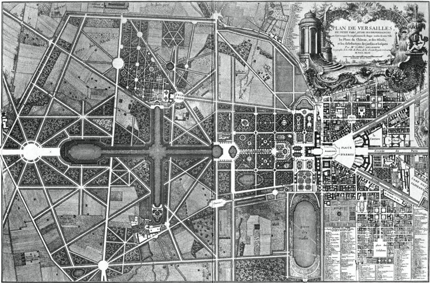
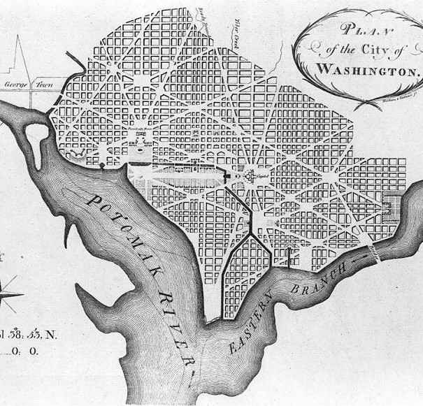
This trend saw a further development in the 17th century, which saw a radical rethinking on the representation of nature within the city. The Catholic Church, which had offered stability of political organisation, and consequently urban form, to Europe after the Dark Ages, had used this history to project itself as the epitome of civilisation whose sanction should determine all worldly affairs. Misuse of this power led to vehement critique of the Church during the Protestant Reformation, which posited that priestly sanction was unnecessary for religious practice, civilisation had been a corrupting influence, and humans should connect back to the original state they held before this corrupting influence held sway. The Bible, which was hitherto available only in Latin, was translated into colloquial languages. The Garden of Eden became a potent metaphor for humanity’s original and happy state, and consequently nature became a foundational constituent in the perception of desirable urban life, making landscape design an integral component of urban design. Parks and gardens were introduced and the streets that focused on public edifices evolved into boulevards: wide roads flanked by tree-lined promenades. This philosophy found its way into garden design, such as at the Gardens of the Palace at Versailles (1632-1670), as well as in urban design as found in the plan designed by the French military engineer Pierre Charles L’Enfant for Washington DC (1791) as the new capital city for the United States of America (Illustrations 3 and 4). These and other such plans had a profound effect, leading to a trend in urban design that came be known as ‘The City Beautiful Movement’.
Wikimedia Commons
Wikimedia Commons
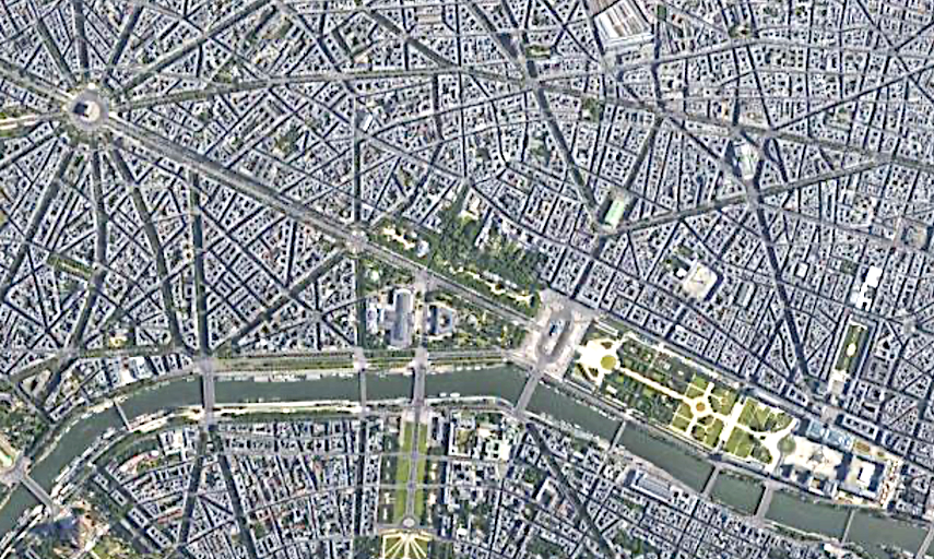
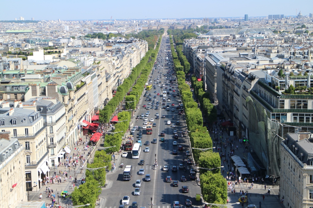
This boulevard-centred trend led to a new element being deployed in urban design: the grand urban axis, a straight and wide boulevard focusing on key monuments at either end, lined with significant buildings, all coming together to make a strong symbolic statement in the centre of a city. One of the most famous early examples in this urban type is the Avenue des Champs Élysées in Paris (Illustration 5). It had evolved into a broad fashionable and tree-lined avenue by the 18th century, starting from The Louvre (currently a museum, but formerly a palace) and the Tuileries Garden, but acquired a significant presence in the city through two subsequent interventions. First, the radiating boulevards carved through the medieval streets of Paris by Baron Hausmann in the mid-19th century integrated the avenue with the rest of the city. And second, the decision at the end of the 19th century to build the Arc de Triomphe as a military memorial to honour those who died in the French Revolutionary and Napoleanic Wars, offered a focal element at the western end that balanced the Louvre and Tuileries Garden to the east.
Google Maps
Suicasmo (CC BY-SA 4.0)
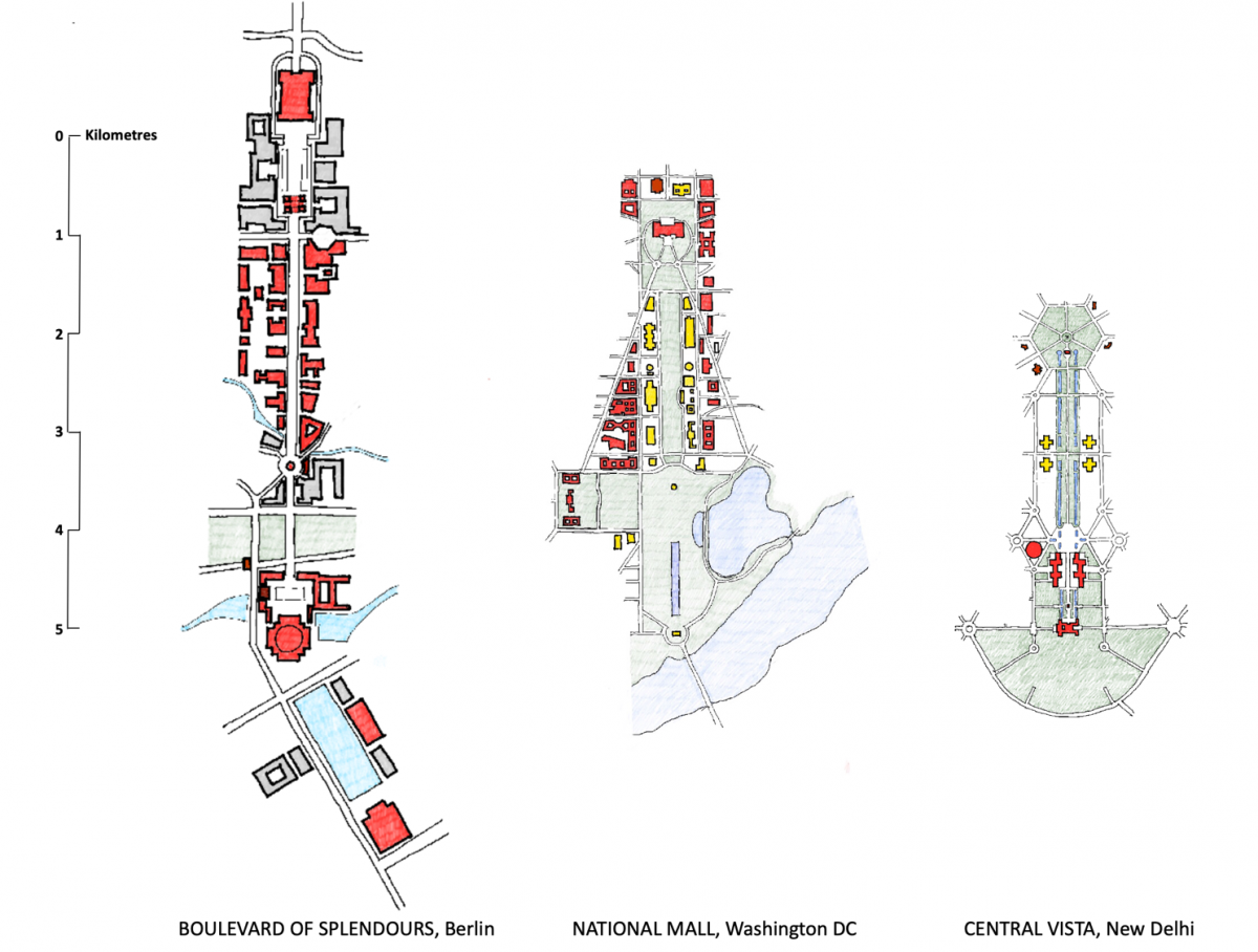
The precedent of Champs Élysées demonstrated a potent possibility offered by the grand urban axis. The bracketing of a boulevard with a monument at one end evoking patriotic sentiment and an edifice at the other representing governance, with significant buildings lining either side, offered a metaphor that empowered capital cities in personifying their significance. In the 20th century, capital cities across the world began to employ the grand urban axis as an urban design device for symbolising the noteworthiness of their regimes. The Central Vista of New Delhi is a prominent example. To understand it fully, a comparison is made here with two other famous grand axes in capital cities. First, we look at the Boulevard of Splendours designed by Albert Speer in the 1930s, an axis that formed the heart of Hitler’s quest to transform Berlin into Germania, a grand capital for the Nazi empire. Second, we will look at the National Mall in the centre of Washington DC in the US.
The relationship between government and citizens is reflected in two choices: which edifices should be brought into focus and what kind of activities should be privileged within the axis.
We see here the curious condition of the grand urban axis being deployed as a political statement by radically different regimes. The Boulevard of Splendours was a fascist project, the Central Vista was originally an imperial project, and the National Mall is a democratic project. How has the same urban element been deployed for radically different ends? The difference lies in the way the constituents of the grand urban axis are selected and configured. The relationship between government and citizens is reflected in two choices: which edifices should be brought into focus and what kind of activities should be privileged within the axis. To understand these choices in the three axes being studied here (Illustration 6), three major components of the grand urban axis will be compared: (i) the focal elements at either end; (ii) the flanking edges that line the axis on either side; and (iii) how the centre of the axis is constituted.
Drawing by author
The Boulevard of Splendours, Berlin
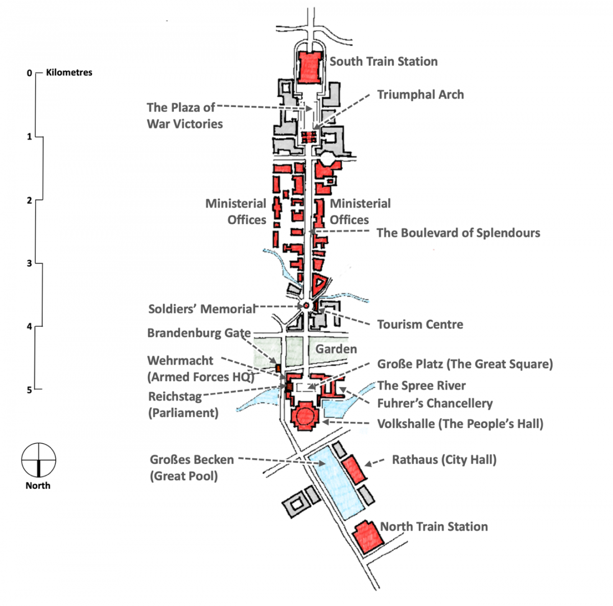
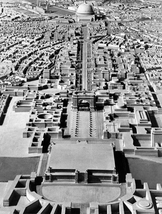
Hitler sought to remake Berlin as a grand capital called Germania, a city whose grandeur would be impressive enough to rank the Nazi Empire as one of the great civilisations of history, comparable only to Ancient Egypt, Babylon and Rome. His favourite architect, Albert Speer, began work on the design in the 1930s. The project envisaged new railways and ring roads, and the centre of the city was to be a new North-South axis over seven kilometres in length. While this axis connected two new train stations at either end, its heart was to be a 4-kilometre long Boulevard of Splendours that linked the seat of government to the north with a grand arch to the south (Illustrations 7 and 8).
Drawing by author
Wikimedia Commons
Focal Elements of the Boulevard of Splendours
At the northern end, the boulevard focused on the Volkshalle (The People’s Hall), a gigantic domed structure, 16 times larger than St. Peter’s Basilica in Vatican City, able to house an audience of 180,000 persons. If it had been constructed, it would have still been the largest building in existence. The foreground of the Volkshalle was the Große Platz (Great Plaza), 350,000 square metres in area, bridging over the Spree River. The ring of grand buildings that joined the Volkshalle in encircling this plaza included The Fuhrer’s Chancellery, The Wehrmacht (Unified Armed Forces) Headquarters, and the existent Reichstag (Parliament) Building of 1894.
At the southern end, the boulevard focused on a large triumphal arch, a military memorial to German armed forces. Modelled on the Arc de Triomphe of Paris, it would have dwarfed its precedent, designed to be 100 metres in height. Both the Triumphal Arch and the Volkshalle would tower over all surrounding buildings.
The axis would have extended beyond these focal elements. The space between South Station and the triumphal arch contained a Plaza of War Victories, designed to display large armaments captured from war enemies. The space between the Volkshalle and North Station shifted the angle of the axis and is and contained a massive reflecting pool flanked by the city hall to one side.
Flanking Edges of the Boulevard of Splendours
The core of the Boulevard of Splendours was to be flanked by ministerial offices on either side. The entire length of the axis was designed to project the presence of government, and all other buildings along its length are military or governmental offices of some kind. The only public facility was the Tourism Centre, whose placement in front of the Soldiers’ Memorial is significant.
The Centre of the Boulevard of Splendours
The Boulevard’s centre was a broad tree-lined avenue kept free of traffic, with all vehicles being diverted into an underground tunnel, constructing a pedestrian promenade whose vantage was well positioned to inspire awe of the edifices of power at either end and along both sides. Military parades were a key feature of the public spectacle of Nazi power and a core function of the Boulevard was to act as a staging ground for such parades.
Analysis of the Boulevard of Splendours
The only part of Germania that was constructed was an east-west boulevard to complement the Boulevard of Splendours. Construction of all other elements had to be shelved with the onset of war, and Germany’s defeat ensured the project never saw the light of day.
In the grandeur of the entire design, the pomp of the focal elements towering above surrounding buildings, the dominance of state institutions, and in the complete absence of public cultural institutions, the Boulevard of Splendours was clearly an enterprise designed to project state power as a patriarchal authority, before whom an obedient and politically passive citizenry could only gaze in awe, taking nationalistic pride in the degree to which they are awestruck.
The National Mall, Washington DC
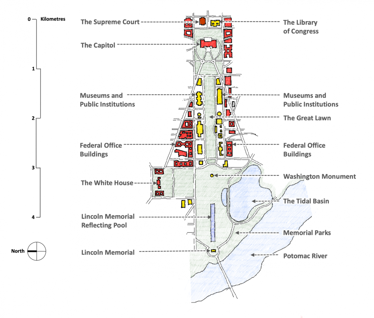
While the grand axis of Washington DC is a constituent of the original 1791 plan for the city by Pierre L’Enfant, what we know of it today (Illustration 9) springs from its radical restructuring under the McMillan Plan released in 1902 (formally titled “Report of the Senate Park Commission: The Improvement of the Park System of the District of Columbia”). This commission, chaired by Senator James McMillan, included some of the country’s top creative professionals: the architects Daniel Burnham and Charles McKim, the landscape architect Frederick Law Olmsted, and the sculptor Augustus Saints-Gauden. The commission adopted several suggestions received from the American Institute of Architects and spent the summer of 1901 touring Europe to gain inspiration from the continent’s grand urban spaces, gardens and manor houses. Before the plan was formally adopted, the commission sponsored a major public exhibition in January 1902 that compared two large models: one of the spaces as they existed and the other as per the proposals of the Commission.
Drawing by author
Focal Elements of The National Mall
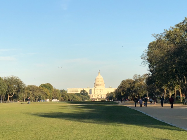
The focal element to the east is the Capitol Building (which contains both houses of the legislature). It is noteworthy that the focus is the legislature rather than the executive. The White House, the office and residence of the President, is along the Mall but is displaced to one side. East of the Capitol Building is a public plaza whose outer edge is framed by the US Supreme Court and the Library of Congress, making the National Mall focus to the east on the triumvirate of legislative debate, justice and knowledge.
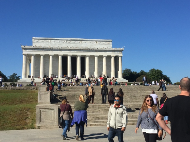
The focal element to the west is not a military memorial. It is a pavilion that commemorates a seminal figure in the history of American democracy, Abraham Lincoln, who steered the country through one of its most difficult phases, the American Civil War, succeeding in the enormous challenge of abolishing slavery while preserving the integrity of the Union of States as a nation.
Flanking Edges of the National Mall
A key decision taken by the McMillan Commission was that a space that is the epicentre of a democracy must represent democratic ideals by being truly public in character, and therefore, must not be dominated by the spectacle of government. This was achieved through a core stipulation of the plan which dictated that any governmental office building cannot come closer than 300 feet (91 metres) to the Mall. This offered room to constitute the built frontage of the mall on either side solely with public cultural institutions, including some of the great museums of the world.
The commission had to fight hard to keep this rule intact. The Department of Agriculture argued that they needed more space and must use all land up to the edge of the mall. When the commission did not permit this, the department argued that they must be allowed to build to a greater height. The commission did not agree to this either, as the greater height would reduce the visual primacy of the public institutions lining the mall. The department had supporters in Congress, and the dispute went all the way up to President Theodore Roosevelt who ruled in support of the ideals the commission was seeking to preserve. The Agriculture Building was eventually built according to the McMillan Plan’s 300-foot setback line and was lowered into the ground so that the greater height could be accommodated while keeping the building in the background when viewed from the National Mall.
The Centre of the National Mall
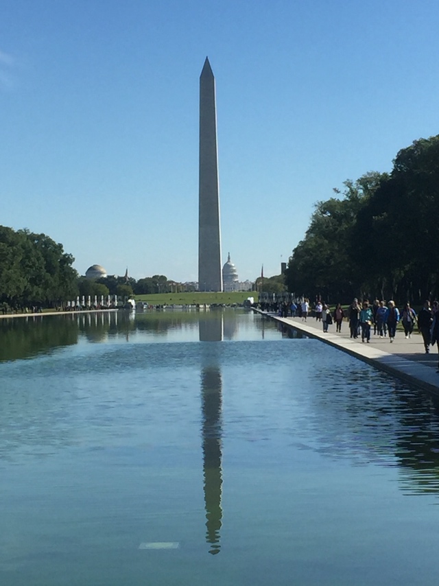
Unlike many other grand urban axes, the centre of the National Mall is not a road that lends itself to military parades: it is a park. That too, a park that does not belong to the city for it is a designated national park, administered by the National Park Service, and named “The National Mall and Memorial Parks.” This park has three segments: to the east is The Great Lawn; in the middle is the Washington Monument (a tall obelisk commemorating America’s first president); and to the west, flanking the Potomac River, are the Lincoln Memorial Reflecting Pool and a Tidal Basin, both surrounded by a set of memorial parks.
The famous urbanist, Jane Jacobs, has pointed out that parks are kept alive by the land uses that surround them. Her study of parks in New York City shows that the liveliness of a park derives from what its surrounding land uses are. When the park is surrounded by lively public uses that have people going in and out throughout the day, this breathes vibrancy into the park.
But when the park is surrounded only by large office buildings, most people stay indoors through most of the working day and are absent outside working hours. The park is then lively only in good weather during lunch time, and at other times is devoid of life, especially outside working hours, increasing the chances of decay and capture by crime and other decadent forces. Since the Great Lawn is surrounded by museums and other institutions that have a constant flow of visitors, it is a vibrant outdoor space throughout the year. On special occasions, the space lends itself to political gatherings when ordinary citizens want to collectively articulate their views and concerns. The fact that such gatherings can take place right under the eye of government is symbolically significant. One of the most noteworthy events that took place there is the culmination of The Great March on Washington in 1963, when Martin Luther King Jr. delivered his historic “I Have a Dream” speech that called for an end to racism. This event is widely considered to be consequential enough to have been a factor in the passage of the Civil Rights Act of 1965.
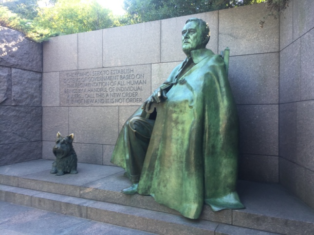
The parks to the west contain a set of landscapes and pavilions that are sites of public cultural memory, including the Vietnam War Memorial, the Korean War Memorial, the Martin Luther King Jr. Memorial, the Franklin D. Roosevelt Memorial, the Jefferson Memorial, and others. These memorials also attract a constant stream of visitors, keeping the park lively at all times.
Analysis of The National Mall
The National Mall deliberately and explicitly embodies the core ideals of a democratic polity. It chooses focal elements that are emblematic of democracy rather than of executive authority or military history. It pushes the spectacle of government into the background, and foregrounds ordinary citizens through public institutions, public memorials and a public landscape. The only governmental building that has a strong presence in the Mall is the Capitol Building whose occupants are determined by the direct expression of ordinary citizens.
Photograph by author
Photograph by author
Photograph by author
Photograph by author
Central Vista, New Delhi: The Original Imperial Plan
In the early 20th century, the British Government wished to make a grand gesture emphasising their dominion over India, hoping that this would help quell the growing quest for independence from the native population. A decision was made to shift the capital from Calcutta to Delhi and establish a new capital city south of the old city. In November 1913, Edwin Lutyens and Herbert Baker were appointed as the architects who would plan the new city and design the major buildings of its centre. This centre would constitute the political heart of the nation, and Lutyens and Baker planned it as the grand urban axis running east-west that has come to be known as the Central Vista (Illustration 10).
Drawing by author
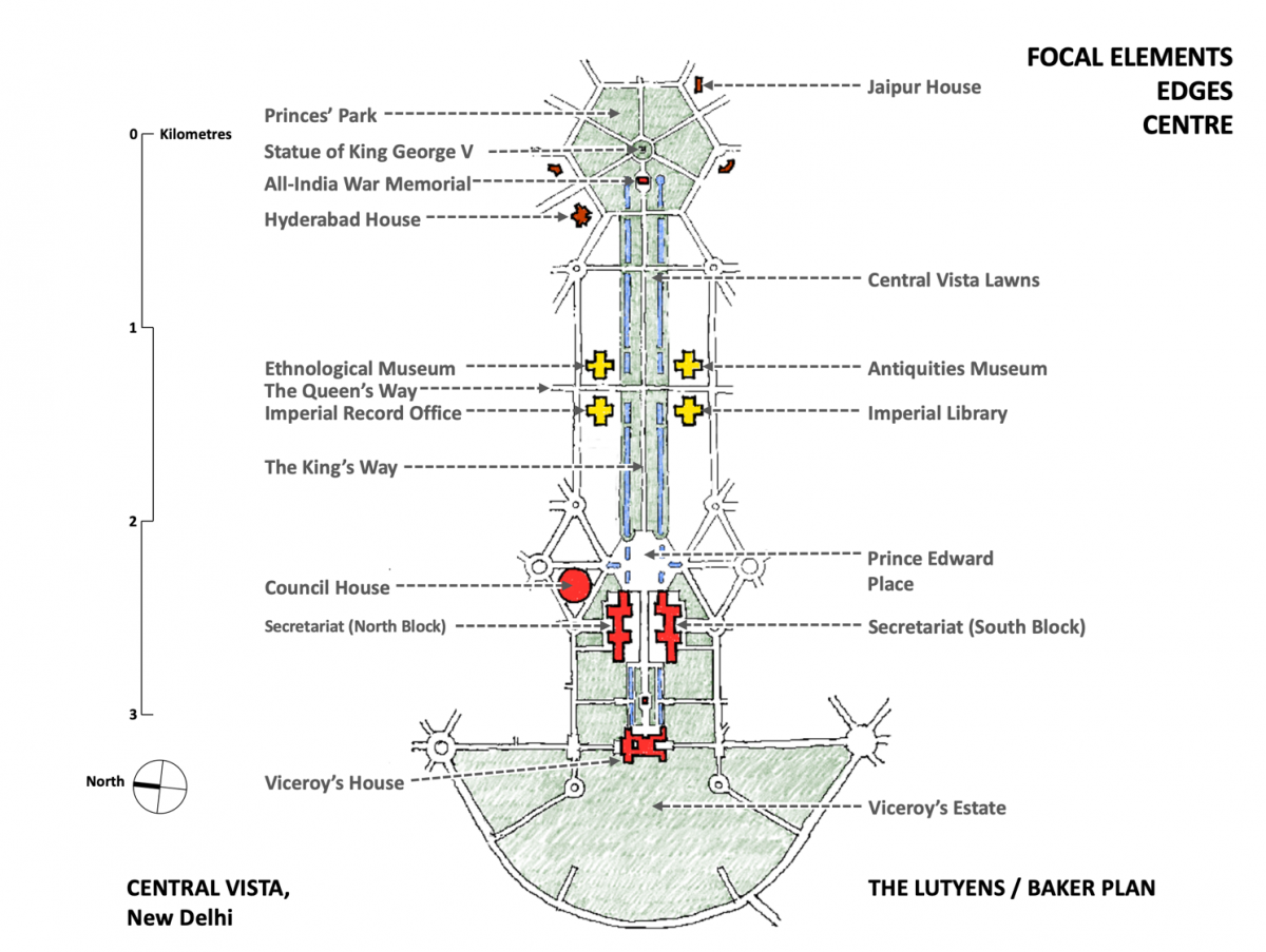
Focal Elements of the Central Vista in the Imperial Plan
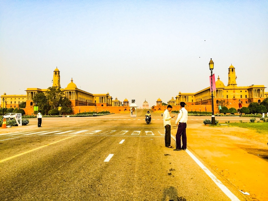
The focus towards the west is on the executive arm of government, with the Viceroy’s House (designed by Lutyens) aligned with the centre of the axis, taking advantage of the topography to be placed on a height at the top of Raisina Hill. The approach up the hill to the Viceroy’s House is flanked on either side by the North and South Blocks of the Secretariat (designed by Baker), with a foreground laid by a ceremonial plaza given the name of “Prince Edward Place” (sometimes referred to as “The Great Place”). Being an imperial project, unlike the National Mall which focuses on the legislature and displaces the executive to the side, the Central Vista does the reverse and focuses on the executive, displacing the legislature to one side. The Council House, which would contain the Legislative Assembly, the Council of State and the Chamber of Princes, lies off the axis to the north of Prince Edward Place. Lutyens and Baker did not get along, and their quarrel affected this section of the axis. Baker felt that the gradient up Raisina Hill should be placed between North and South Blocks as that complemented their composition. Lutyens wanted the gradient pushed further east so that the Viceroy’s House was clearly visible from the vista. Eventually Baker prevailed, as a result of which only the dome of the Viceroy’s House is visible from Central Vista, and one has to move past North and South Blocks to perceive the entire edifice.
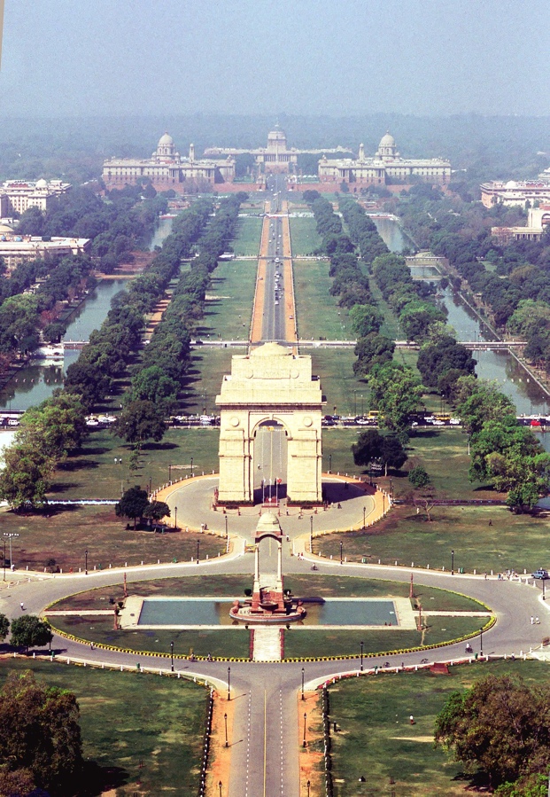
The east end of the axis follows the precedent of the Champs Élysées to deploy the focal element of a triumphal arch as military memorial: The All-India War Memorial, built to commemorate Indian forces who died during World War I.
This memorial was placed slightly west of the centre of a hexagonal park, giving central position to a cupola housing a statue of King George V. Plots around this hexagon were offered at a subsidised rate to the heads of the princely states as a gesture to gain their support, which led to the hexagon being named ‘The Princes’ Park’. Some of these buildings precede Independence, designed as a part of, or immediately after, the original imperial project. Hyderabad House was designed by Edwin Lutyens and completed in 1928 and Jaipur House was designed by Arthur Blomfield and completed in 1936.
Photograph by Sondeep Shankar
Flanking Edges of Central Vista in the Imperial Plan
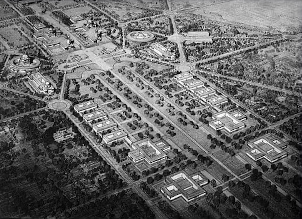
A set of linear lawns and reflective pools flank either side. At the junction in the centre of the vista, the adjacent plots in the four quadrants around the junction are given to cultural institutions to create a culture hub as the core of Central Vista. The four institutions planned were the Imperial Records Office, the Antiquities Museum, the Ethnological Museum, and the Imperial Library. Only one of these, the Imperial Records Office (currently known as ‘The National Archives’) was built as a part of the original project; it was designed by Lutyens and completed in 1926.
These institutions were not entered directly from the main vista, they were entered from the road that cuts orthogonally across its middle, but these entries were close enough to breathe life into the vista’s lawns. The Lutyens-Baker plan clearly visualised the vista as a civic space, with a public landscape along its entire length that was rendered vibrant by the cultural hub at its centre.
Reprinted with permission of Centre of South Asian Studies at University of Cambridge
There are different depictions of usage of other plots that line the vista. The drawing of an aerial perspective shown here (Illustration 11) seems to depict some office buildings that append to the cultural institutions (this drawing is of an early design, for it also proposes a cathedral behind South Block, lined with a circular arcade in order to symmetrically reflect the Council House; a proposal that was later shelved). Subsequent plans show these plots designated as residences for senior members of government. In either case, buildings on these plots were set back further from the vista when compared to the culture hubs, were smaller in size and lower in height, and were entered from the parallel roads to the north and south of the vista. They would be hidden behind the trees and would not have a visible presence on the main, vista which would remain a predominantly civic space with the prominent buildings confined to the cultural hub.
The Centre of Central Vista in the Imperial Plan
A road, that was called ‘The King’s Way’, runs down the centre of the vista. The road that intersects it at right angles in the centre of the vista, the intersection at which the cultural hub is located, was called ‘The Queen’s Way.’ The King’s Way, while serving as a traffic route on normal days, was intended to be a boulevard for ceremonial processions. An article in 1921 in The Times, London, talking about the Viceroy’s House as a focal point, remarked, “Processions approaching the building—India is a land of ceremony and processions—will have it in view for two miles as they move along a stately avenue flanked by trees, waterways, and fountains.” The goal was to lay out an elegant promenade that symbolised the glory of British Empire.
While the Central Vista between the Viceroy’s House and the All-India War Memorial was the epicentre of the imperial plan for New Delhi, the axis was meant to extend further east, skirting the edge of Purana Qila to touch the western bank of the Yamuna River. While there are busy roads today that mark this extended alignment, this extension of the vista as a landscaped promenade was never executed.
Analysis of Central Vista in the Imperial Plan
In the ideological impulses that underpin its design, the imperial plan for Central Vista sits in between The Boulevard of Splendours and the National Mall. Being an inherently imperial project, it shows scant interest in emphasising democratic ideals and in focal elements and centre follows precedents set by the Boulevard of Splendours although it is far removed from the megalomaniacal scale of Nazi Germany’s fascist ambition. It chooses executive authority and military memory as its focal elements. In the same vein, along its central axis it places a boulevard for the processional display of political and military authority.
But in its choice of the flanking edges, Central Vista shows similarity with National Mall in foregrounding cultural institutions and a public landscape. This may have had its roots in the arrogant claim that British colonialism was a mission to bring civilisation to the colonies, but at the moment of Independence, India inherited a space that was designed to inherently be a realm of public culture at its core.
Central Vista: The Current Condition
A refrain often heard when the current redevelopment is being debated is that the Central Vista is a colonial construction and therefore need not be respected as heritage when deciding what to do with it. The fact of the matter is that independent India unhesitatingly appropriated the colonial project right from the start. This was a spontaneous outpouring from the first moment when in 1947 on our first day of independence people gathered at the plaza in front of North and South Blocks to celebrate the nation’s newly won freedom. This plaza was subsequently renamed Vijay Chowk (Victory Plaza).
Over seven decades, this precinct has been uniquely Indian, hosting highly significant milestones of independent India’s history, and the memory of those years make it unequivocally a part of India’s heritage.
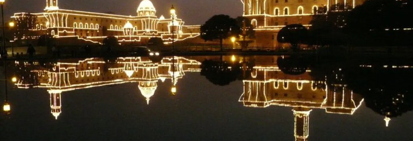
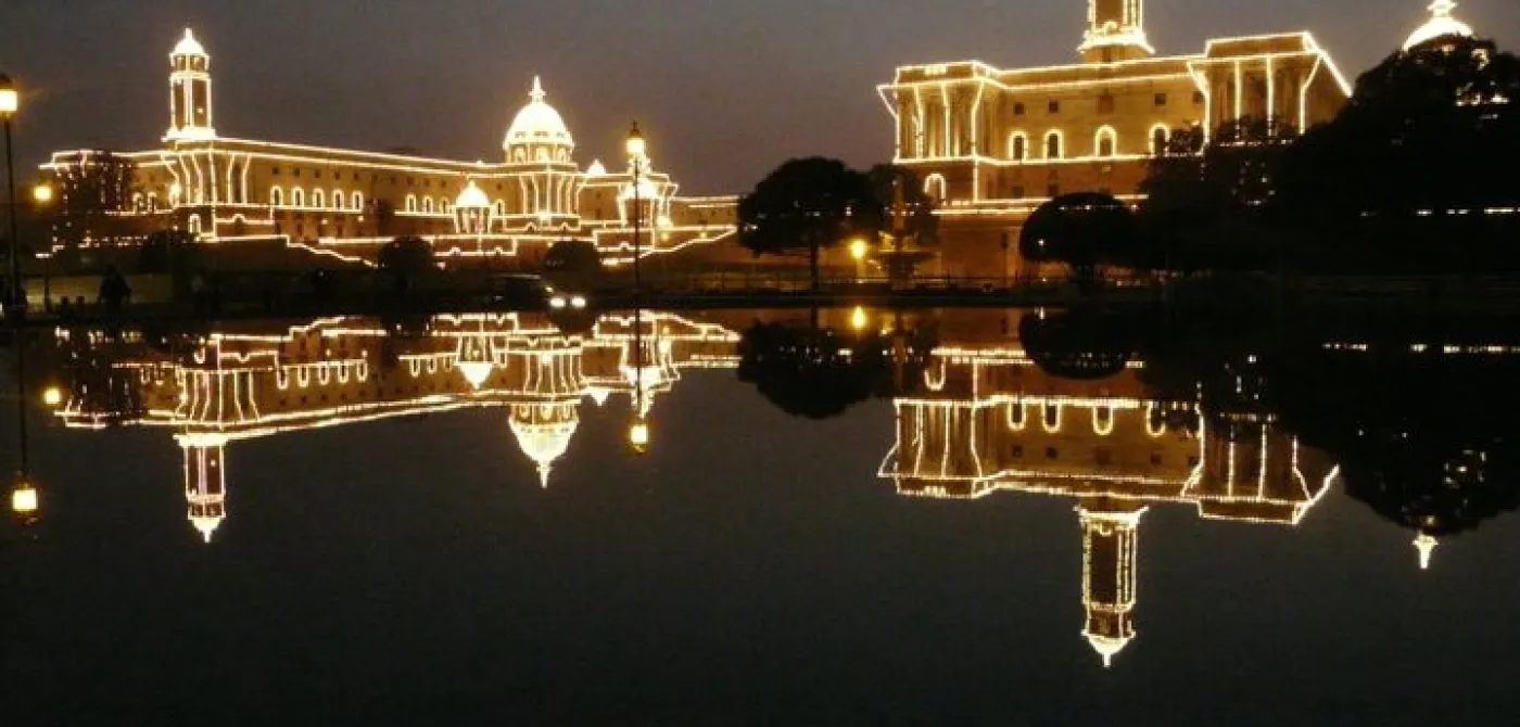
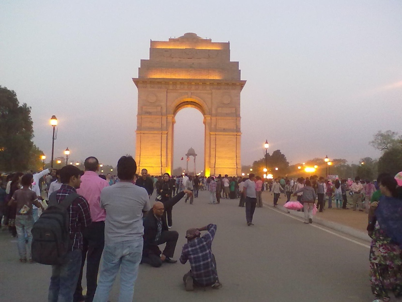
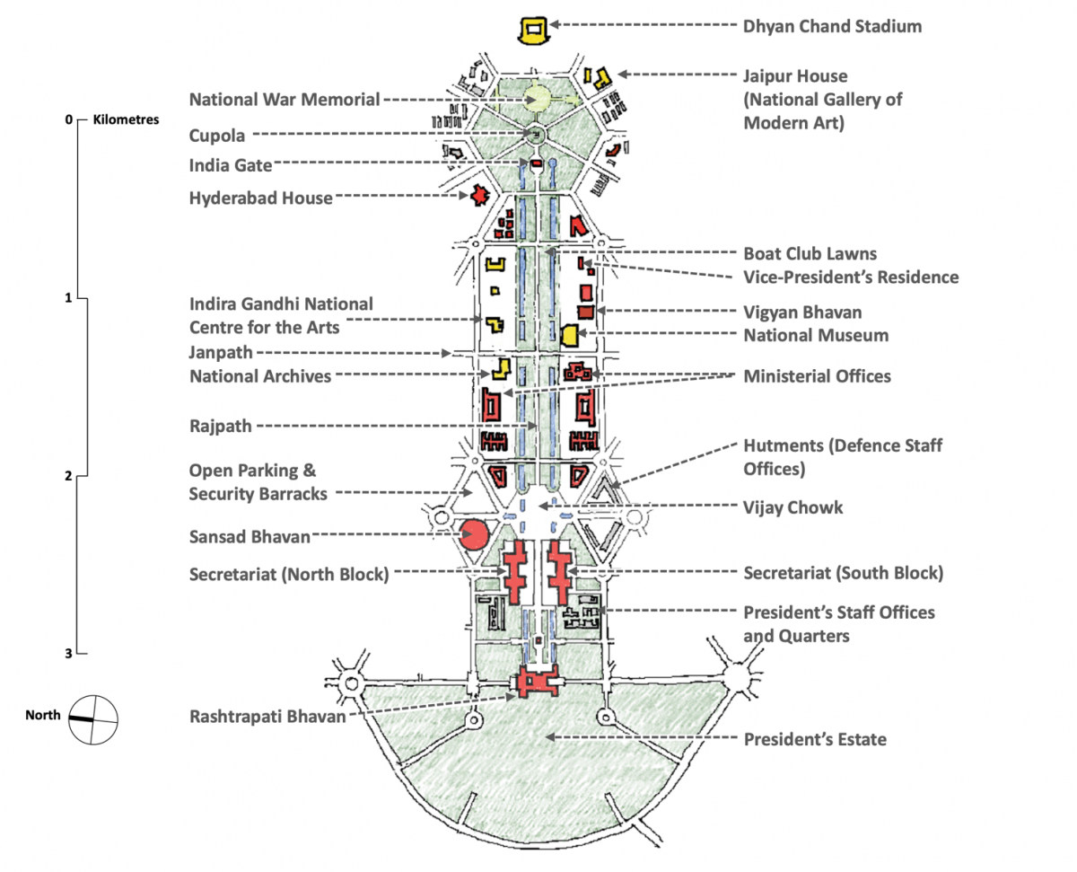
All the other spaces were similarly appropriated, by both government and ordinary citizens (Illustration 12). The Council House was turned into Sansad Bhavan, India’s Parliament House, to become the location for the nation-building debates of the Constituent Assembly and all parliamentary discussions since Independence. The Viceroy’s House became Rashtrapati Bhavan, the office and residence of the President. The Secretariat Block became the independent government’s executive offices. The All India War Memorial became India Gate, an Indian military memorial that currently houses the Flame of the Immortal Soldier. The cupola that housed the statue of King George V had the statue removed and has since been left empty.
The lawns of the vista evolved into a popular scene for public protest and have hosted some of the nation’s most significant expressions of mass public sentiment, although the government in the last several years has been trying to suppress the protests at this site citing concerns for security. The hexagon around India Gate now houses a children’s’ playground and is a very popular park. The King’s Way was renamed as Rajpath (The Way of Governance) and The Queen’s Way was renamed as Janpath (The Way of the People).
Over seven decades, this precinct has been uniquely Indian, hosting highly significant milestones of independent India’s history, and the memory of those years make it unequivocally a part of India’s heritage. This is no doubt assisted by the fact that the architectural expression of Lutyens and Baker did not cling to an orthodoxy of European classicism, and felt compelled to foreground many architectonic elements from Indian tradition such as chhajjas, chhatris, jharokhas, domes, and red sandstone as a material.
Drawing by author
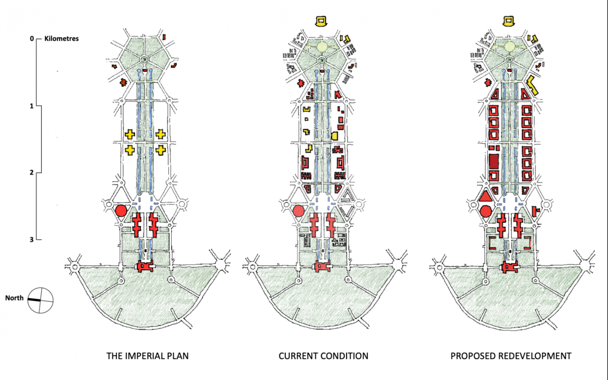
Additional buildings have been added to the Central Vista over the years. The original concept of the cultural hub at the intersection of Rajpath and Janpath was retained, but executed slowly and not in its entirety. The National Archives in the northwest quadrant dates back to the original project. The National Museum was constructed in the southeast quadrant in 1960. In the 1980s the northeast quadrant, along with adjacent plots in that segment, was given to the Indira Gandhi National Centre for the Arts. An international design competition led to the project being awarded to Ralph Lerner, an architect from the US. Only a segment of the Lerner design has been constructed till date. The southwest site designated for the Imperial Library never materialised. The library remained in Kolkata and has since been renamed The National Library of India. In 2012, the cultural hub was compromised by government offices taking over this quadrant, which now houses the Ministry of External Affairs.
As ministries have expanded over the years since Independence, additional buildings were added to accommodate their offices, ranging in height from five to seven floors. None of them are entered from the vista, and all take their entries from Dr. Rajendra Prasad Road and Maulana Azad Road, the two roads parallel to the vista on the north and south. There has been no attempt made to make these additions cohere to unifying urban design goals. Their architecture is largely mediocre, their maintenance and current condition is abysmal, and their placement does not respect the symmetry of the vista, although this is somewhat mitigated by their being set back behind the rows of trees with fairly wide gaps between them. Another building added to this zone is Vigyan Bhavan, a conference centre for holding government functions.
While the post-Independence additions to Central Vista are far from ideal, it remains a public landscape imbued with heritage, memory, and the affection of those who inhabit or visit it.
The area around the India Gate hexagon has also changed considerably. A substantive segment of the hexagon park has been appropriated for the National War Memorial. The Dhyan Chand Stadium has been added at the eastern end of the vista, blocking any visual connection to a possible extension of the axis up to the Yamuna River. Hyderabad House has been taken over by the government as a location for hosting state guests. Jaipur House has been extended and converted into the National Gallery of Modern Art. Patiala House has become a courthouse. Military housing and other miscellaneous buildings have come up in the other plots.
Haphazard development has also occurred at the western end. Two triangular plots of land on the southern edge of Vijay Chowk have hutments that are used as offices by defence staff. Many structures have also come up within the President’s Estate to accommodate staff residences and quarters. The park adjacent to Sansad Bhavan has been displaced by car parking and security barracks serving Parliament.
While the post-Independence additions to Central Vista are far from ideal, it remains a public landscape imbued with heritage, memory, and the affection of those who inhabit or visit it.
Central Vista: The Proposed Redevelopment
The currently planned redevelopment project springs from an advertisement issued in early September 2019 by the Central Public Works Department inviting bids from architects for a redevelopment of the entire precinct. This notice inviting bids defined an ambitious schedule, aiming to design and construct the entire project within four and a half years, and even the selection of the architect moved at a supercharged pace. By the third week of October, HCP Design, Planning and Management Private Limited (HCP) was awarded the contract to design the entire redevelopment.
At the time of this writing, no data on the design has been released in the public domain, and whatever is known (Illustration 13) is gleaned from screenshots of online presentations to selected audiences made by HCP. All cultural institutions are to be removed from the main vista between Vijay Chowk and India Gate, and the entire stretch is to be largely covered with a set of identical seven-storey office towers, each wrapping a central courtyard, that will collectively constitute a new Central Secretariat housing all ministerial offices. The National Museum, The Indira Gandhi National Centre for the Arts, and all existing buildings along this stretch will be demolished to make way for these new buildings. The only building that is being preserved is the National Archives, but it is unclear what use will be assigned to it. Vigyan Bhavan is also slated for demolition, and a new National Conference Centre will replace it directly west of National Archives. The Indira Gandhi National Centre for the Arts is being relocated to a new building on a plot facing the India Gate hexagon.
Sansad Bhavan is being discarded as the site for Parliament, and a new triangular Parliament Building is proposed in the adjacent plot to the east. A new Prime Minister’s Office, with an attached garden, is proposed directly south of Vijay Chowk. Plots behind North and South Block are being cleared of the haphazard development that had occurred there, and new residences for the Vice-President and Prime Minister are proposed.
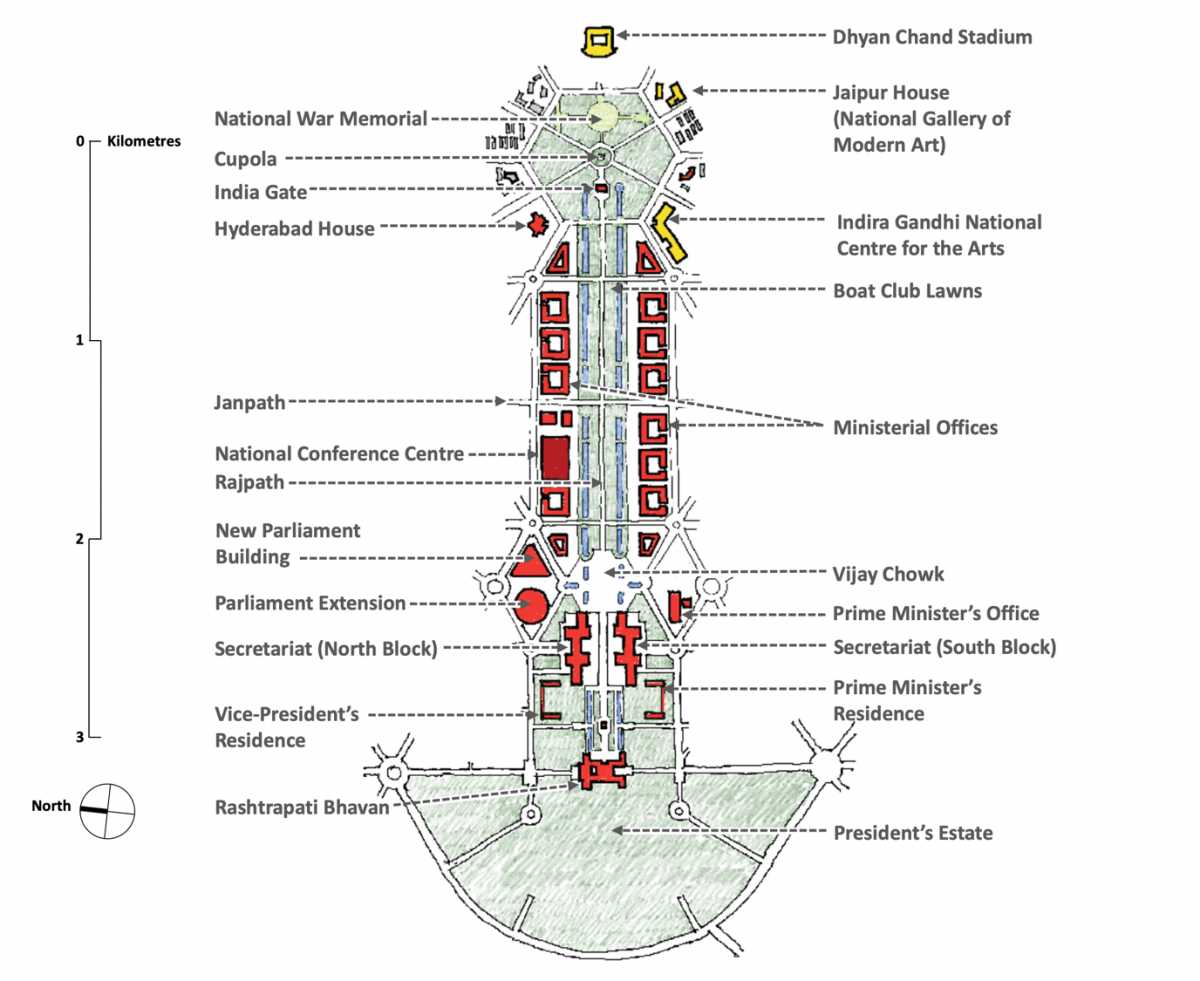
Drawing by author
By removing all public cultural institutions from the main vista and lining it with government offices, the vibrancy of the vista’s lawns is likely to be substantially reduced. In a visual reading of the drawings presented, the ground footprint of governmental offices is far greater than that currently existing. All of the new office buildings are seven floors high, whereas only a couple of the current buildings reach that height, with other office buildings between five and six floors. The current buildings have large gaps between them and are at varying distance from the vista. The new proposal has very small gaps between buildings, and they present an aligned and almost continuous wall of construction to the vista. In the earlier condition, a large part of the surrounding construction is low rise, such as the cultural institutions, Vigyan Bhavan and the Vice-President’s Residence. In the new plan, most of the construction is uniformly seven floors high. HCP has argued that the buildings are set back far enough behind trees that their parapets will not define the horizon, but this argument assumes a vantage point of the centre of Rajpath, whereas from the lawns the view through tree trunks will be dominated by the new buildings. The monumentality of governmental architecture in Central Vista will be far higher in the new development.
With a larger footprint and greater average height, the overall built up area of governmental offices will substantively increase. This apparent increase in area is hard to understand, given that in an online presentation on the project made by HCP on 13 July 2020 to the Maharashtra Association of Schools of Architecture (MASA) it was claimed that the impact of the redevelopment on the working population within Central Vista would be a negligible increase of 2%, from 50,000 to 51,000. The increase in built up area appears to bear no resemblance to a nominal 2% rise. Data on new constructed areas in the redevelopment has not been placed in the public domain at the time of this writing.
Drawing by author
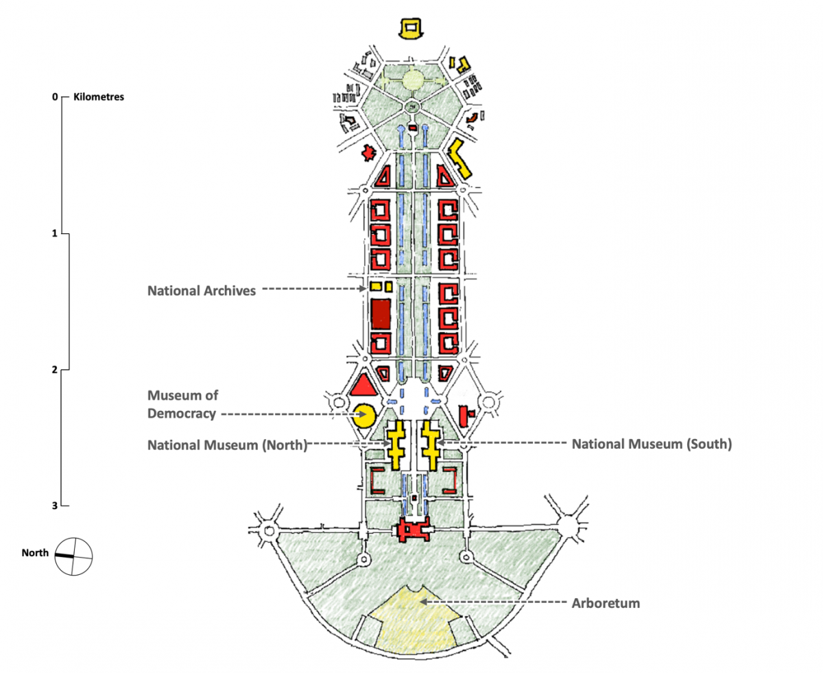
The project regrettably pursues a design where cultural institutions and a vibrant public landscape give way to the visual spectacle of government. HCP has argued an intent to increase public space through some claims that have not been substantiated by subsequent governmental action. In an interview early into the project, HCP suggested that Parliament will move into a new building and Sansad Bhavan will be converted into a Museum of Democracy. In the MASA presentation (Illustration 14), HCP made the following assertions on cultural space in Central Vista: (i) The National Archives Building will be preserved in its current use; (ii) North and South Blocks will be converted into the new National Museum; (iii) About 50 acres of land will be carved out from the President’s Estate to make a new public arboretum; and (iv) the original plan to extend the vista till the Yamuna River will be executed, encircling around the Dhyan Chand Stadium to reach a new public garden created on the river bank. In an online interview on 27 June 2020, HCP was asked whether the government has formally ratified these proposals, and an ambiguous response was offered that these proposals form an integral part of several presentations to government and nobody has contradicted them as yet.
HCP is no longer talking about the Museum of Democracy. In a legal submission made in February 2020 seeking environmental approval to build the new parliament building, the government asserted that the new building is an extension of the old one, and several parliamentary functions will remain within the existing Sansad Bhavan so that the two buildings function as a single complex. The Delhi Development Authority (DDA) has issued legal notifications on the change of land use zoning needed to execute the project. In these notifications, the usage of the site on which National Archives sits has been changed from ‘Public/Semi-Public’ to ‘Government Office’, the usage of the sites on which North and South Blocks sit has been preserved as ‘Government Office’, and the notification does not contain any proposal to carve out public land from the President’s Estate. When contradictory statements are made, official legal pronouncements by governmental bodies have to hold sway over informal remarks by private individuals, and therefore the analysis here relies on HCP’s drawing modified to reflect the change of land-use notification of the DDA (Illustration 15).
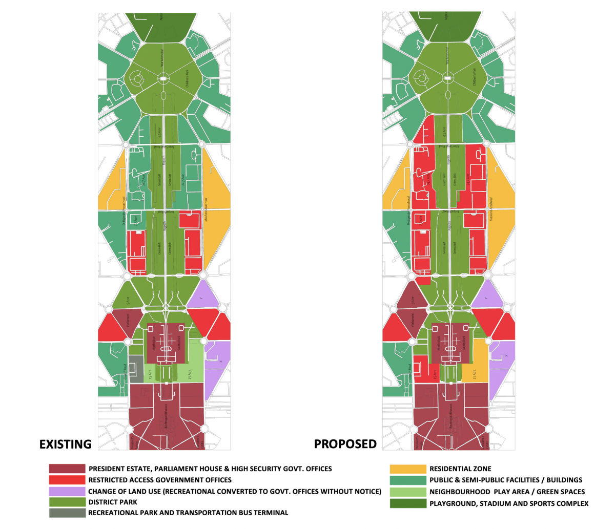
This notification shows a substantial loss of public land in the Central Vista: over 80 acres of land are shifted from public uses to governmental use. This cannot be compensated by a public garden on the river bank or an arboretum entered from a road west of the Presidential Estate, for the loss of public land occurs within the main vista precinct, whereas these two gardens are not spatially contiguous with the Central Vista and will have no impact on the perception of its public character.
Central Vista: What Does the Redevelopment Portend?
To appreciate what the redevelopment portends, we must carefully examine the choices made in the design of the redevelopment and the procedures the project has followed.
Drawing by author
The project inherited an imperial design and can do little about the choice of focal elements of the grand axis. But it could take cognition of the fact that the reassessment is now being made by a democracy and reflect on how the constituent elements of this grand urban axis could be reshaped so it nudges what was originally an imperial design toward the ideals of democracy. If it had sought to do this, one would have expected the project to have replicated the commitment shown by the McMillan Commission in Washington DC in 1902 to pursue a design imbued with the spirit of democracy, where public participatory experience is in the foreground and the spectacle of government is pushed to the background.
Unfortunately, the project does the reverse, reducing public space in the main vista, eliminating the cultural hub, and dominating the core of the precinct with the spectacle of government (Illustration 16). If the original imperial design lay between the ideals of the Boulevard of Splendours and the National Mall, the redevelopment pushes the Central Vista more towards the spirit of the Boulevard of Splendours than it does toward the spirit of the National Mall. This choice is doubly unfortunate given that the Lutyens-Baker design for the Central Vista was founded on a spatial core of public culture, and the design could have chosen to restore the sanctity of this core.
Supporters of the project argue that its grandeur will epitomise the development of our nation, and every citizen can consequently take pride in it. Development is a process that is meant to empower people, and a public project can reflect this empowerment only through offering participatory and emancipatory spaces at its core. Development is, at its heart, an ethical project whose ethics are compromised when the dominant ethos of an urban design project reduces the public to mute spectators awestruck by the pageantry of governmental architecture.
Given the lack of disclosure and debate, it is impossible to know what intentions drive the proponents of the Central Vista Redevelopment.
Does this reflect an authoritarian turn being taken by our democracy? One is compelled to fear so when one juxtaposes design choices with procedures the project has followed. On procedure, the McMillan Commission has set compelling benchmarks for democratic protocols on public projects: openly articulate and debate the vision and ideals of the project before launching it, seek suggestions before starting the design, take those suggestions seriously, spend time to study best practices across the world to define benchmarks the project must meet, and publicly share the project design and details before it is formally and legally ratified. On the contrary, we find stark gaps in the process followed by the Central Vista Redevelopment. To name a few:
- A project that fundamentally reshapes the physical infrastructure of Parliament, ministerial offices of central government, and their surrounding precinct has been conceived, launched and driven forward without any debate in Parliament.
- The established precedent of such projects being placed under the oversight of a Joint Parliamentary Committee is being ignored.
- The project has proceeded thus far under opacity and secrecy. The government is yet to articulate the vision that initiated the project. The basis for selecting the architect is yet to be disclosed. The project cost is being kept a closely guarded secret. Designs, drawings and areas are yet to be placed in the public domain for scrutiny by citizens.
- There have been no public hearings or consultations on the project in the true spirit of the word. Whatever presentations have been made have been by the architect and not by the government, have been made to selected audiences, have not been preceded by disclosure of data so prior study can enable informed debate, and have not been widely advertised in mainstream media in advance. There has been no mechanism established to accept public feedback on the project.
- The project has reached the stage where land use changes to implement it have been legally notified, applications have been made to statutory authorities seeking permissions necessary to start construction, and the process to solicit bids for the first phase of construction has been launched. This is reducing the project to a fait accompli before any details have been made available to citizens.
- The project radically reshapes a listed Grade-1 heritage precinct. Established good practice in heritage conservation demands that design be preceded by a detailed heritage audit by qualified conservation professionals. This has been disregarded.
- Claims have been made on needs that justify the need for the project. For example, a new Parliament is claimed as necessary because more seats are needed in both houses to ensure that electoral representation stays proportionate to population growth, and this cannot be accommodated in the existing heritage building. Yet, there has been no disclosure of any rigorous study that validates this claim.
Given the lack of disclosure and debate, it is impossible to know what intentions drive the proponents of the Central Vista Redevelopment. One would like to make the charitable assumption that they pursue this project in what they perceive to be the best interests of the nation. But then, one would be compelled to dwell on the ringing words of former Supreme Court Justice H.R. Khanna in his famous dissenting judgment in the ADM Jabalpur case of 1976, and paraphrase those words to state, “The greatest danger to liberty lies in insidious encroachment by men of zeal, well-meaning but lacking in due deference for the ideals of democracy and the rule of law.”