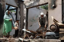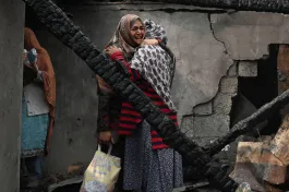
The inhuman spectacle of a photographer repeatedly stomping on the lifeless, bullet-ridden, body of Moinul Haque, shot by police in Assam in September during a drive to evict supposed encroachers, has taken a backseat as political discussions turn to save the state from ‘illegal immigrants’. Over decades, the political milieu in Assam has been orchestrated in such a fashion that anyone growing up in the state cannot escape the propaganda of large numbers of ‘land-hungry Bangladeshis’ programmed to relegate Assamese Hindus into a minority.
The development discourse of the state remains embedded in a willful ignorance of history, ecology, and migration patterns. The simultaneous production of such ‘knowledge’ and ‘ignorance’ is perpetuated by the power structure. In such a milieu, stomping on a dead man becomes carnivalesque for the ‘knowledgeable’ photographer. For the peasant, such ignorance becomes a matter of life, livelihood, and honour.
Cultivating the ‘wastes’
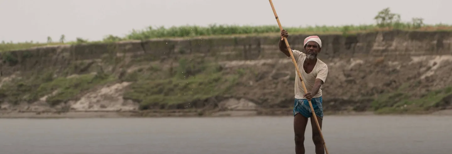
Assam’s 78,523 square kilometres (sq. km.) is described as being divided into two physical divisions: the ‘plains’ and the ‘hills’. The plains comprise the Brahmaputra and Barak valleys and the hills cover the North Cachar Hills and Karbi Anglong. Within this somewhat archaic description lie the chars, the temporary river islands of the Brahmaputra and its tributaries, where land and water are entwined in a permanent flux. If the geography textbook awareness of terra firma, land as distinct from the sea, disciplines us to imagine a binary between land and water (Lahiri-Dutt 2014), on the chars, terra firma becomes permeable, and lives and livelihoods are negotiated in a fluvial regime of impermanence. The imaginaries of our ‘disciplining’, understanding, and politics fail in interpreting the chars and its dwellers.
Under the gaze of the colonial administration — and not discouraged by the Assamese elites — labour migration was facilitated first to the tea gardens and later to the flood plains of the Brahmaputra.
The chars are an inseparable part of the Brahmaputra floodplains, but large-scale habitation for cultivation started only when they became a part of the colonial construct of ‘wastelands’ — land, which by lying ‘idle’, had become an economic wastage (Whitehead 2010; Chakraborty 2012). These wastelands gradually became an inevitable part of revenue administration in colonial Assam, initially for tea plantations and thereafter for cultivation. Under the gaze of the colonial administration — and not discouraged by the Assamese elites — labour migration was facilitated first to the tea gardens and later to the flood plains of the Brahmaputra.
While the plantation labour was largely made up of Adivasi communities from different parts of colonial India, the floodplains were populated by peasants from erstwhile East Bengal. By 1951, peasants of East Bengali origin amounted to anything between a tenth to a sixth of the population of the state (Goswami 1994: 71-2). They were settled on over six million acres of wasteland (Census of India 1951), including on the chars. (On the last count, in 2003-04, there were 2,251 char villages with an estimated population of around 25 lakh.) This settlement produced the present demographic feature that as one follows the Brahmaputra downstream, from the upper riparian Tinsukia district to the lower riparian Dhubri district, the Muslim population in the floodplains and the chars increases.
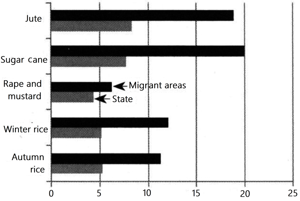
The large-scale settlement brought in more land under the plough in the Brahmaputra valley as well as introduced newer crops and varieties with higher yields. Historically, the increase in acreage was especially marked in four districts of the Assam plains where the settlement of East Bengal-origin peasants was greater and for the crops they cultivated (Figure 1).
While the settlement of these peasants transformed the agricultural landscape of the state, it also produced several sensitive issues: differing models of land use, and recurrent floods and erosion in the floodplains increased pressure on land, accompanied by regulatory gaps and ambiguity about the administration of land in the floodplains and the chars. These ecological problems soon enmeshed with the complex nationality question in Assam as the peasants were overwhelmingly Muslim.
The expanding river
State Disaster Management authorities point out that the Brahmaputra has expanded over the decades. In 2006, the river flowed over 6,080 sq. km, up from 4,850 sq. km. between 1963 and 1975, and 3,870 sq. km. during 1921–28. This increase has eroded large areas in the valley, averaging 8,000 hectares each year (Chakraborty 2018). This frightening picture speaks of the levels of landlessness, poverty, penury and migration in the Brahmaputra valley in Assam.
While all the communities suffer from erosion, the implications of such suffering vary in terms of the religious affiliations of the victims. Muslim victims get transformed into ‘Bangladeshis’.
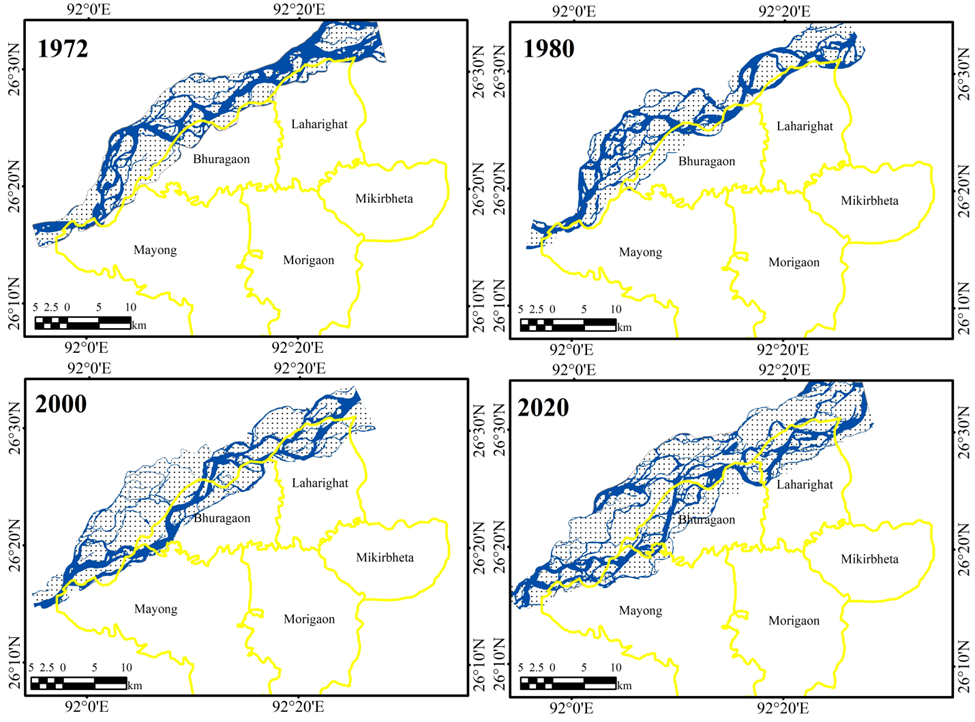
The geomorphological characteristics of the Brahmaputra floodplains provide an unending supply of fuel to the biopolitics of producing the myth of the ‘Bangladeshi’ and its imaginaries of hate and ‘invasion’ of Assam. The uncertain floodplains and impermanent chars have kept the peasants mobile, migrating in search of relatively safer areas within the river system or to the ‘mainland’ in search of existence and livelihood. Take, for instance, Laharighat block of Morigaon district, a Muslim-majority district that has a long history of settlement by peasants from eastern Bengal dating back to colonial times. Between 1955 and 2020, more than 30% of land in Laharighat was lost to the Brahmaputra, forcing residents to migrate for survival (Momin and Chakraborty 2021). While all the communities suffer from erosion, the implications of such suffering vary in terms of the religious affiliations of the victims. Muslim victims get transformed into ‘Bangladeshis’, identified as ‘illegal immigrants’ by state and civil society alike.
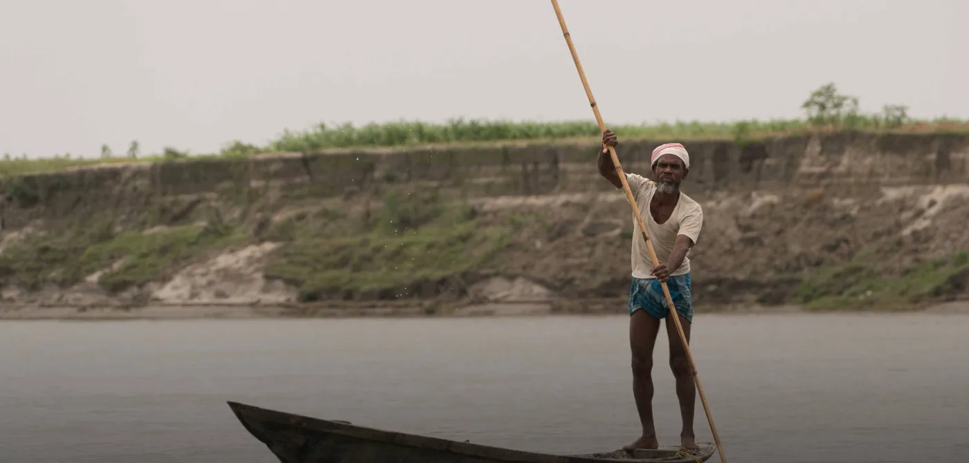
In Dholpur 3 village of Darrang district’s Sipajhar block, where Moinul Haque and one other person were shot during the eviction drive, residents told us that people from several districts of the Brahmaputra valley had settled there over the decades. The overwhelming majority of them moved when their erstwhile habitations and land were flooded and eroded by the river. For instance, Lokman Ali (name changed) narrated how his family moved in the late 1970s to Sontoli char in Kamrup district from Andabhanga char in Barpeta district. From there, yet again as victims of erosion, they moved to Dholpur in the 1980s.
“We purchased land from people who already possessed them by dokhol [encroachment]. The only difference is they left the land fallow and we cultivate it.”
Nur Alam (name changed), whose family moved to Dholpur after their home in Morigaon district, on the opposite bank of the Brahmaputra, was eroded in 1993, challenged the popular narrative in media that more than 70,000 bighas of land were ‘encroached’ in the village and its surroundings. According to him, less than 21,000 bighas of land remained today after erosion by the Brahmaputra. Alam said that non-Muslim communities had settled on more than 700 bighas. Much of this land was fallow, he said, as cultivation in the chars is an uphill task.
Many of the erosion-affected Muslim peasants had settled in and around Dholpur by purchasing land from non-Muslim communities, including Nepalis, who were largely involved in livestock rearing. The majority of these land transactions, though, were devoid of any official deeds. As Qurban Mia (name changed), said, “If every year we lose land due to erosion where do we go? We will have to survive somewhere.
“No Muslim peasant settled here are by dokhol [encroachment]; rather we purchased land from people who already possessed them by dokhol. The only difference is they left the land fallow and we cultivate it.”
Gaps in land regulations
After the incident in Sipajhar, media outlets reported a statement by state authorities that those possessing land in Barpeta, also a Muslim-majority district, would not be provided with government land. This narrative perfectly fits into the discourse of ‘land-hungry Bangladeshis’ who, despite possessing land, seek to usurp even more government land through illegal occupation, ultimately to make the Assamese Hindus a minority in the state.
However, gaps in land revenue regulations in Assam mean that in the floodplains and the chars, even if one possesses a plot of land with a permanent deed, the impermanence of such land complicates claims to ownership.
One of the earliest regulations in eastern India on administering the flood plains as well as the chars was the Bengal Alluvion and Dilluvion Regulation of 1825, applicable in Assam for 32 years between 1897 to 1929. The Assam Land and Revenue Regulation (ALRR) 1886 has also been another foundational document for land administration. But neither of the two regulations explicitly dealt with the issues of land erosion or the emergence of new land through accretion, generating conflict over land ownership, possession and revenue administration. This led to litigation and judicial decisions, producing certain broad frameworks, which themselves are open to reinterpretation.
In the absence of regulations, when a char emerges, it is the property of the state […] In practice, any land that re-emerges is almost instantaneously settled on, given the high rate of erosion of the chars.
According to the regulations, if a piece of land was eroded, but subsequently new land was formed at the same site, the new land would be the property of the original possessor, provided the site was not abandoned. There were inconsistencies in how this was interpreted. The Assam Land and Revenue Regulation of 1886 provided for the deputy commissioner of the district to reduce the revenue due on the eroded land. In practice, though any appeal for such abatement of revenue carried the possibility of loss of ownership as it could be considered an indication of abandonment. If revenue continued to be paid for the eroded land, under the Goalpara Tenancy Act 1929, claims on the site lasted for 20 years after the erosion or three years after the reappearance of land, whichever was less (Chakraborty 2009).
Curiously, when the Assam Temporarily Settled Areas Tenancy Act 1971 replaced colonial-era legislation on land and tenancy, it refrained from mentioning the chars. In the absence of regulations, when a char emerges, it is the property of the state and is marked as a ‘grazing reserve’ or its use is guided by the Land Settlement Policy Resolution. In practice, any land that re-emerges is almost instantaneously settled on, given the high rate of erosion of the chars and mobility of the dwellers (Chakraborty 2009). On each occasion that the state has attempted land revenue settlement in the chars and the floodplains — in 1979, 1983 and 1994 — the process was stalled in the name of protecting the land from ‘land-hungry Bangladeshi immigrants’ (Chakraborty 2009).
Feigning ignorance
Any democratic government, keen to the circumstances of Assam’s history, ecology, and migration, should question itself before aiming a bayonet at the chest of a so-called encroacher. But, alas, the government seems busy in transforming Assam into the latest police state.
Exclusivist exclusionary politics in Assam post the partition of 1947 has long incentivised a process of identifying fellow citizens as strangers. The emerging politics of Hindutva provides the icing to this much-nourished ahistorical imagination. No paper trail, either through lists of suspect ‘D’ voters, the Aadhaar card, the Electoral Photo Identity Card, or the National Register of Citizens, can resolve the citizenship question in Assam if the social milieu is purposefully implanted with the ‘virus’, and the myth of invading Bangladeshis is embedded in the mind of the populace.
Such deliberate ignorance brings to mind Peter Galison (2004), a historian of science, who emphasised how ignorance is not the absence of knowledge but rather knowledge denied or denigrated. The incident at Sipajhar points out that the ruling dispensation in Assam is programmed towards a deliberate spread of ignorance to suit its ideology of hate and (mis)governance.