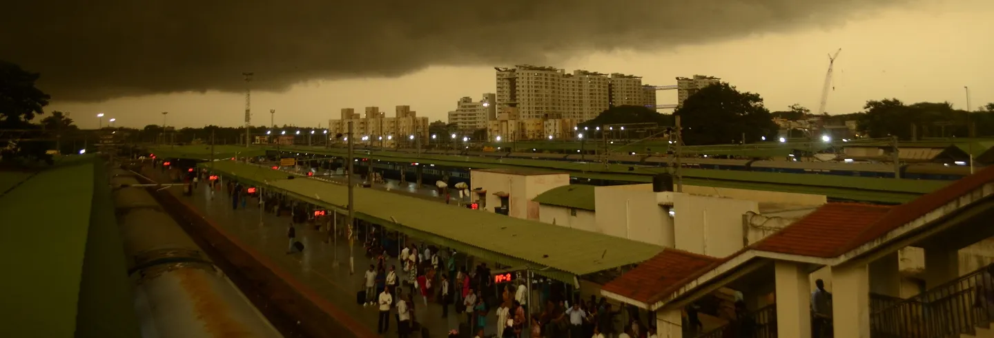


September 2022 saw Bengaluru in the headlines on the local, national, and international media when incessant rain inundated large parts of it. Bengaluru’s flooding received immediate attention from all quarters because the information technology (IT) heart of the city was affected.
A slew of articles and blogs on social and print media pointed to failures of urban planning and management, unfettered and un-informed urbanisation, lack of water and land management, inefficient governance, corruption and collusion, encroachments and land-use and building law violations, and the elite capture of public policy. As has been the norm, the city authorities sprang into action and the state government promised a master plan with an end-to-end approach to managing existing storm-water drains and building new ones to eventually link them to the Cauvery through the Dakshina Pinakini river (the Ponnaiyar in Tamil Nau). A special task force to monitor the maintenance and expansion of storm-water drains was announced.
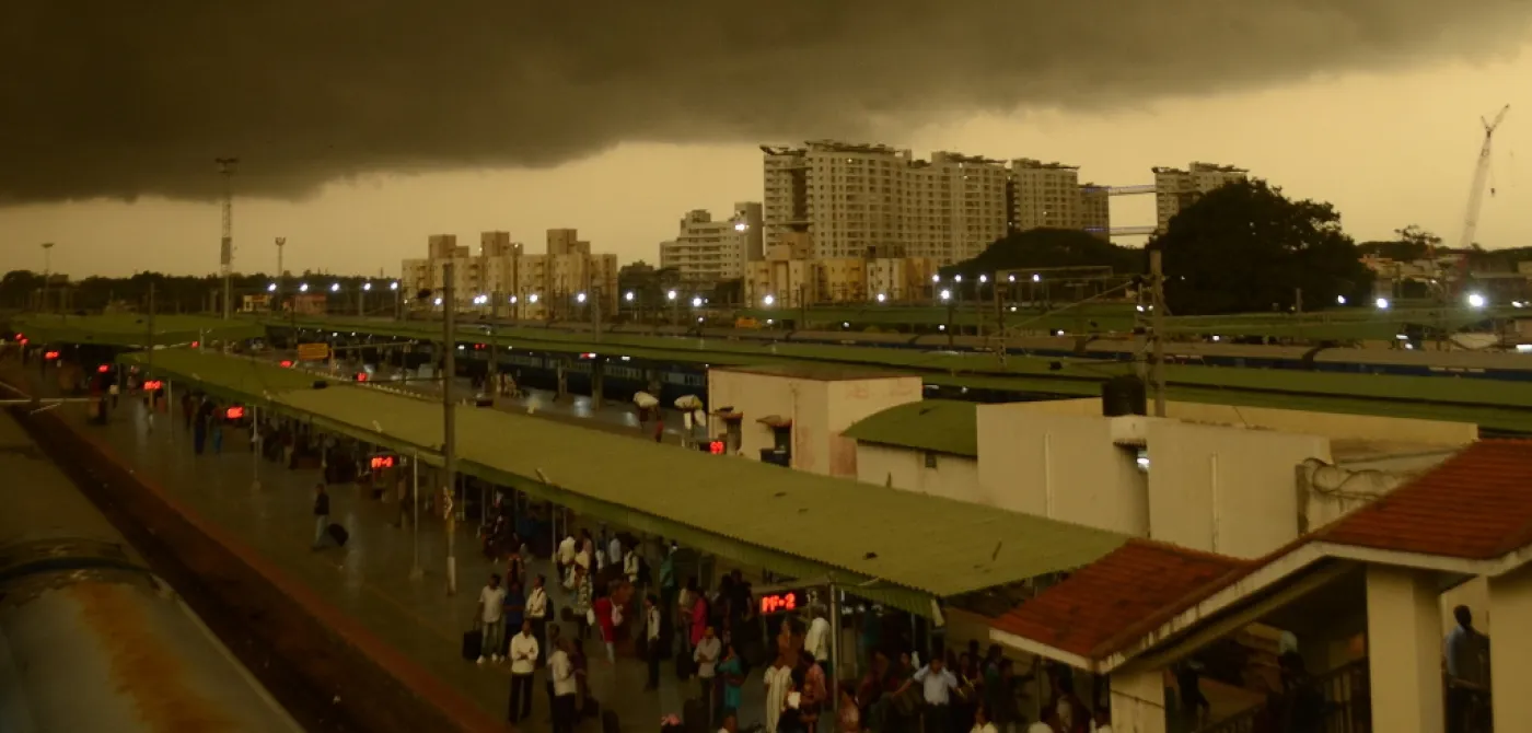
Figure 1: Effects of Climate Change and Responses in Southeast Asia
Bengaluru’s story is not an isolated one. Extreme climate events and responses—well intentioned as well as knee jerk—are normal across India and Southeast Asia (Figure 1). Even as city planning is blamed, the fundamental need to render our cities liveable remains. In a context where the rich, the poor, and the state are complicit in flouting city plans, questions about how cities can be re-imagined through socially just and environmentally sustainable planning are being raised.
The everyday city is a manifestation of contradictions and ambiguities—manufactured and perceived—within the master plan. It is a result of subversive urbanisation, marked by zoning and building violations and weak governance instruments, all of which work against public welfare.
To address these questions, we unpack the formal planning processes to argue for a) an overhaul of the current approach to planning; and b) a ground-up reading and planning of the city. We highlight two linked systemic failures requiring immediate attention. One, the “everyday city” that unfolds dynamically is not the one that is envisioned in the master plan although the master plan is hostage to this everyday city. The everyday city is a manifestation of contradictions and ambiguities—manufactured and perceived—within the master plan. It is a result of subversive urbanisation, marked by zoning and building violations and weak governance instruments, all of which work against public welfare. Second, there are externalities that the master plan is forced to accept as “givens”. The metro rail, a white elephant, is a classic example of such an externality. While the state and central governments had a say in planning the metro rail, the city and its citizens were rarely consulted.
Planning Cities through Master Plans
In India, the statutory master/development plan, often referred to as the land-use plan, is the dominant planning tool to steer urban growth. The approach is top-down and centralised through organisational and institutional frameworks operating in silos, arguably a colonial legacy (Mohan, Pellissery and Gomez, ed, 2021; Roy, 2009; and Watson, 2009). While the focus is on allocating land-use categories (main and permissible) to land, 1The master plan allocates main and compatible land uses to parcels of land. The latter are referred to as permissible land-uses. the colonial legacy separating the city’s planning from elected representatives continues with para-statals such as development authorities preparing master plans across cities. Several scholars have argued that the planning in the global South, India being no exception, is a part of the problem of cities becoming increasingly unliveable.
It is no surprise then that several master plans have been controversial and delayed by courts even as cities have continued to grow in the vacuum so created. For example, the Shimla Development Plan 2041 was recently criticised for allowing development in core areas and green belts. While Shimla’s ecological fragility has been seen in recent flash floods, building collapses, and loss of lives, the Master Plan 2041 is criticised for exacerbating these catastrophes. Consequently, in May 2022, the plan was stayed by the National Green Tribunal.
Similarly, the floods in Chennai have been attributed to inefficient urban planning. Reclassifying water bodies into areas for residential layouts and other developments has resulted in unfettered and shoddy urbanisation marked by a loss of drainage and green cover. A new master plan for the city is being developed with a focus on reducing the impact of natural disasters that are due to climate change. The situation of Bengaluru is not any different. The current plan—the Revised Master Plan 2015 (RMP 2015)—is outdated. Its successor, the RMP 2031, was approved by the government of Karnataka but the approval was withdrawn soon after.
In a nutshell, planning needs to guide the mindless and unfettered urbanisation occurring across cities of the global South or respond to it, an objective that assumes heightened importance with increased climate change events. While cities across the country have embraced climate action planning to prepare themselves for ongoing and expected climate events—with Mumbai, Chennai, and Bengaluru leading the conversation—there is a risk that these plans will err along the same lines as the earlier master plans.
As in other cities, when Bengaluru flooded, the muddled and chaotic spatial growth that had followed an outdated and static plan was criticised. Rightly so because the spatial growth model had been oblivious to the natural systems that had provisioned the city in the past.
To ensure that the faults of master plans are not repeated, it is important to not just examine and foreground these faults but also craft alternative pathways—fostering inclusion and resilience—to plan the city. Using the case of Bengaluru, this article analyses planning contradictions and resulting ambiguities and externalities to argue that there are no quick fixes to making our cities inclusive and resilient and, by extension, liveable. The value of understanding planning for the city from the ground up cannot be overstated. Such an exercise should have commenced some time ago. That such a process will be painstakingly slow and messy does not undervalue its relevance.
Ambiguous and Contradictory
As in other cities, when Bengaluru flooded, the muddled and chaotic spatial growth that had followed an outdated and static plan was criticised. Rightly so because the spatial growth model had been oblivious to the natural systems that had provisioned the city in the past. Developed by the Bangalore Development Authority (whose legal authority to prepare a master plan for the city has been contested time and again), the plan remains an abstract version of a city vision disconnected from, and oblivious to, realities on the ground. Further, plan implementation remains a challenge for various reasons—financial and land constraints and the absence of implementable master plan schemes, among others.
The RMP 2015 attempted a reconciliation between the everyday city and its plan. It made a bold departure from earlier plans to advocate mixed land use development by introducing newly coined zones such as mutation corridors, commercial axes, and mixed-use residential developments. 2Mixed-use urban development advocates multiple compatible uses that are physically and functionally integrated. Mixed use can be applied to a parcel of land, space, or building. Mutation corridors are designated main and radial arterials that allow for commercial, industrial, residential, transportation facilities, and other urban amenities with minimal restrictions. Commercial axes are major and minor roads that are already commercial and can be further commercialised through industrial and transportation land uses such as IT, biotechnology, corporate offices, cinemas, multiplexes, and other high-end development. The residential (mixed) category, while proposing residences as the main use, allows for commercial, industrial, transportation, and urban amenities as ancillary uses (to 30% of the built-up area).
The objective of introducing these zones was to align and respond to the existing mixed-use character of the city. However, with the exception of agro mandis, hazardous and heavy manufacturing industries, railway stations, depots, airports, and cargo terminals, all other land uses were allowed. This has led to rampant commercialisation along the designated mutation corridors, commercial axes, and mixed residential zones, triggering Bengaluru’s infamous traffic snarls and, more recently, floods. The flooding hotspots located to the East, South-East, and North-East of the city are along/adjacent to the Outer Ring Road (ORR) and its adjoining radial roads, many of which are designated as mutation zones. These corridors now host a dense mix of IT industries and commercial areas, which are the result of zoning ambiguity and legal contradictions that allow nearly all land uses.
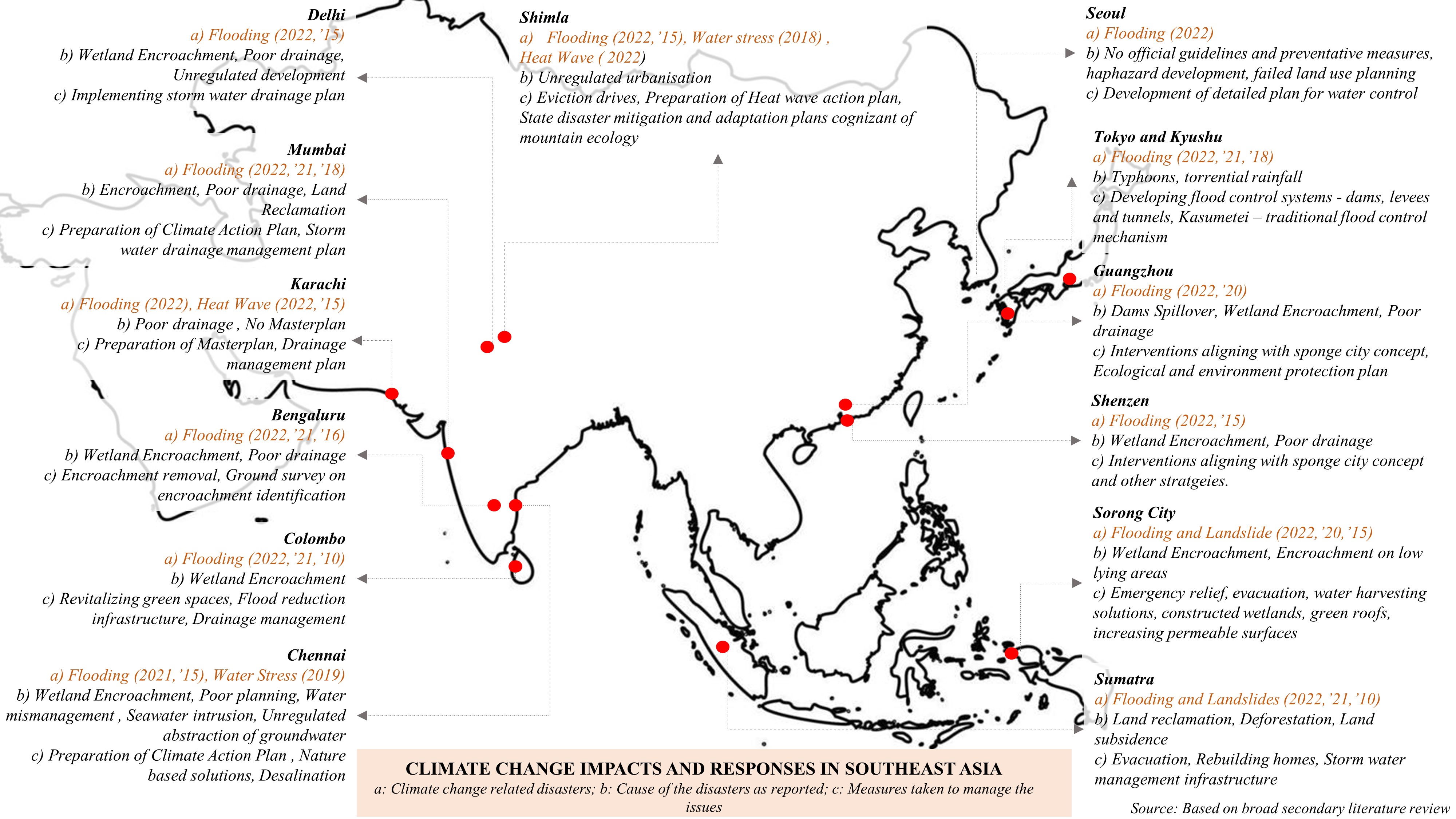
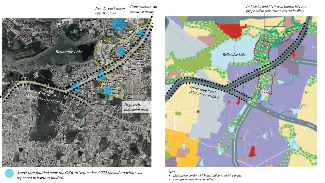
Figure 2: Area of enquiry: Bellandur
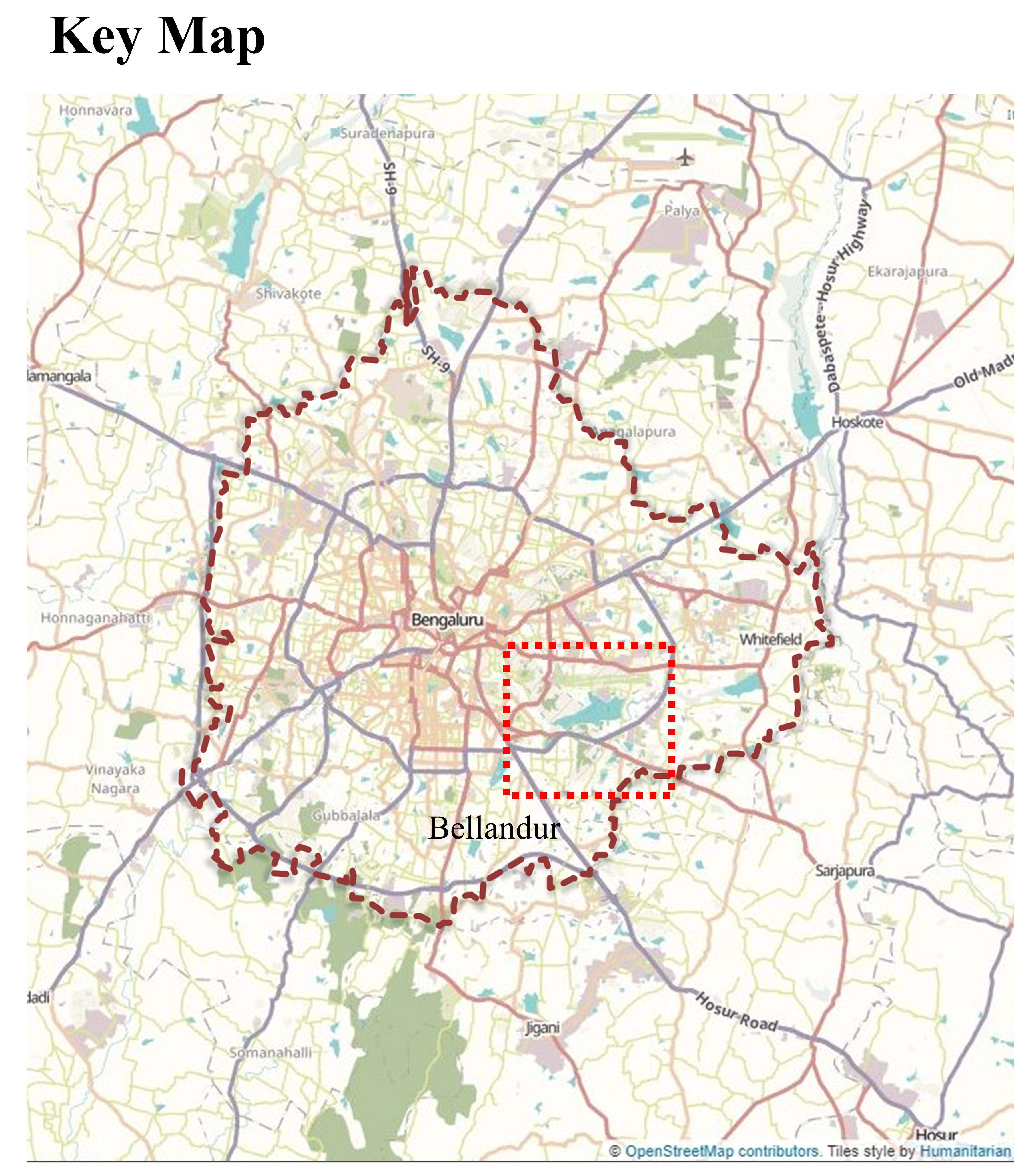
Figure 3: Bellandur Lake and Surrounding Areas
Planning is the Problem
A closer look at the zoning regulations points to internal contradictions in the plan. 3Zoning and attendant regulations are urban planning tools deployed to guide the physical development of land and the uses it can host. While the RMP 2015 demarcates storm water drains and adjoining areas (including valleys) as “sensitive areas”, it also proposes specific land uses for these areas in contradiction to this. The sensitive area around Bellandur Lake allows for industrial development, thus flouting the provisions of a sensitive nature of the landscape (Figure 2). An overlay of the earmarked sensitive/valley areas with the mutation corridor zone along the outer ring road and the recently flooded hotspots demonstrates this. These contradictions have resulted in built areas that do not align with the plan (Figure 3). A 2022 satellite image of the area shows a new IT park under construction in a sensitive area that has been assigned to the hi-tech industrial land-use category.
What unfolds on the ground contradicts what the plan proposes, and then what is on the ground becomes the reality for the next plan.
Planned or otherwise, the city continues to explode spatially—either violating the plan or facilitated by it. An overlay of the proposed and existing land-use maps of the RMP 2015 and RMP 2031 and a comparison with a recent Google Earth image (Figure 4) points to considerable deviations from the plan proposals. It is difficult to ascertain whether these are facilitated by the land-use change clause in the Act or if they are a part of the permissible land-use categories, or if they are violations of the master plan. 4Section 14-A of the Karnataka Town and Country Planning Act, 1961 allows change in land use from commercial or industrial to residential or from industrial to commercial. Further, the Act states that if the applicant pays the stipulated conversion fee and informs the local planning authority prior to effecting the change, the permission for such change of land use or development is deemed to have been given. The net result is a city that is not planned. Notably, as the master plan gets revised, these deviations are recorded as the existing land use, which serves as the basis for the land-use proposed for the next 10-15 years. Thus, the revision process is hostage to the shoddy development triggered by the contradictions and ambiguities in the plan.
Figure 4: Bellandur and Surrounding Area: Proposed Land Use in RMP 2015, Existing Land Use in RMP 2031, and Google Earth Image 2020
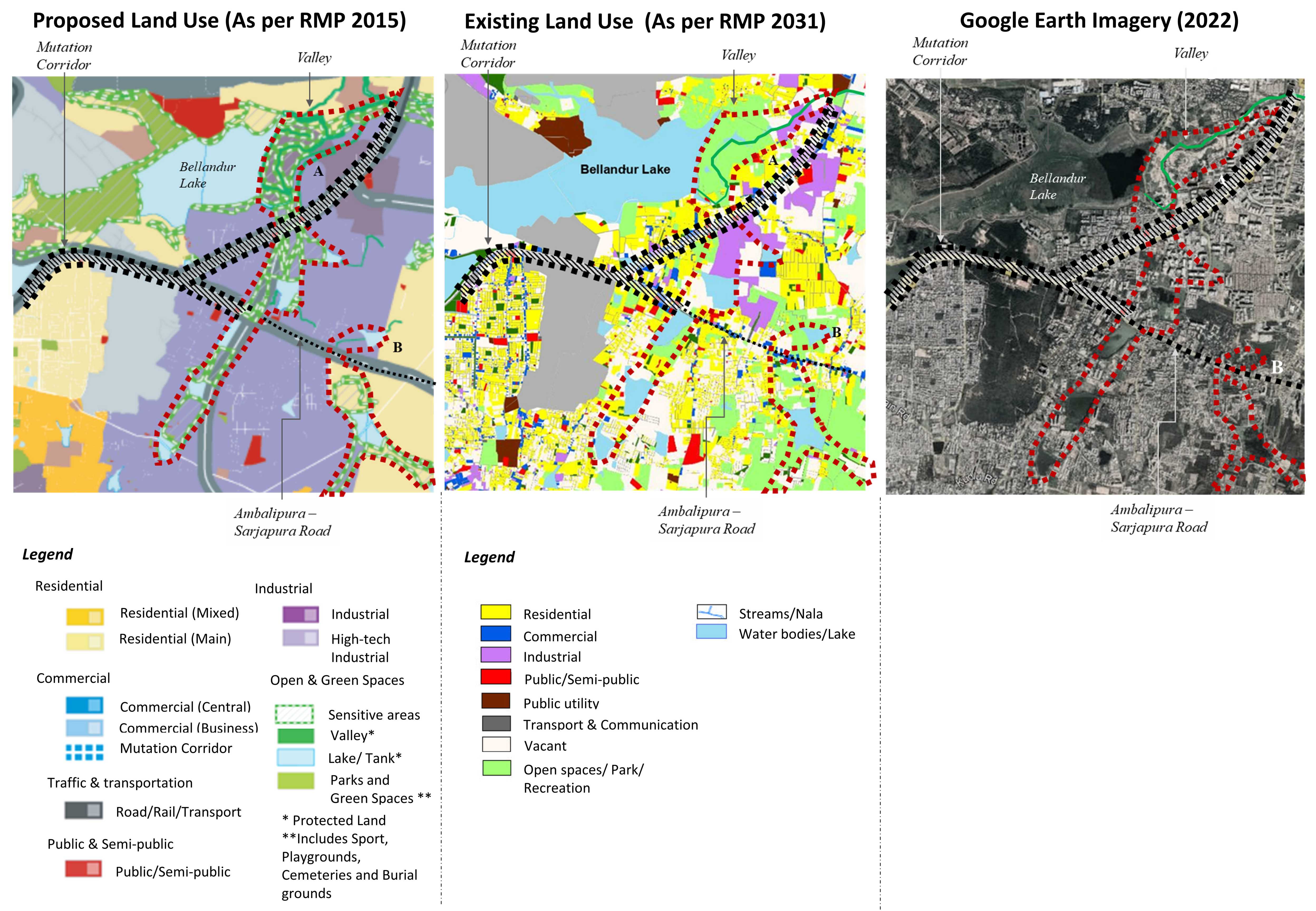
Table 1: Deviations in Land Use Recorded in the Master Plans
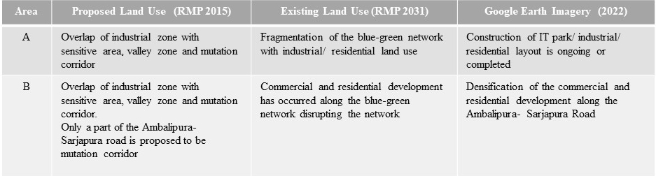
The above analysis (Table 1) points to a vicious cycle—what unfolds on the ground contradicts what the plan proposes, and then what is on the ground becomes the reality for the next plan. Breaking this cycle would require, we argue, a systemic overhaul of the planning process and its statutory framework.
Adding Fuel to the Fire
Master plans often have to contend with externalities (emanating from national and state policies) that have a bearing on the form and function of a city. A classic example is that of metro rail infrastructure. In 2006, the National Urban Transport Policy proposed metro rails for all cities with a two million-plus population. The Union Government, in 2014, announced financial assistance for constructing metro rails in all million-plus cities. By 2015, metro rails were approved for 50 cities, to be implemented through special purpose vehicles established as joint ventures (50:50) between the union and state governments.
In Bengaluru, the first line of the metro was operationalised in 2011. For the RMP 2015, the metro plan was a given. The master plan envisaged that the metro stations could result in more than one central business area (CBA) for Bangalore. Accordingly, it identified four CBAs to be realised through the allocation of a higher floor area ratio of 4 within a 150-metre radius of the stations. Although realising a floor area ratio of 4 remains a challenge even today, the metro lines dictated the form and the function of the city, as can be seen in the RMP 2031—for instance, the metro (Phase 1) has transformed the Kagadaspura-Indira Nagar area from a defence and residential zone into a predominantly commercial zone.
It is critical to evolve grounded and inclusive processes that go beyond the familiar quick fixes and knee-jerk reactions.
A systemic overhaul of the planning process is imperative. It should account for the everyday city to which the master plan contributes implicitly and explicitly. In addition, the new process should embrace the challenge of climate change and its impact on inequity in the city. Evidence from across the globe points to how cities will be at the forefront of suffering from the effects of climate change. The flood in Bengaluru was a mere illustration of how the city will continue to be impacted.
There are no familiar pathways or readymade solutions to making our cities liveable. It is critical to evolve grounded and inclusive processes that go beyond the familiar quick fixes and knee-jerk reactions. The 74th Constitutional Amendment Act, 1992 with its provisions for planning and governing a city region, city, and ward serves as an entry point for a system overhaul.
The Way Forward
The 74th Constitutional Amendment Act, 1992 is premised on the principle of subsidiarity. Operationalising this principle will require a marrying of planning at the city region scale with that at the ward scale. Such a process should necessarily foreground the city’s ecology through a detailed mapping of the city region. Once mapped, it should act as a “positive constraint” to build expansion at the city and ward scales. In Bengaluru (and other Indian cities) ward committees are in the process of being constituted. The Bengaluru municipality mandates that a monthly meeting of the ward committee be held on the first Saturday of every month. In August 2021, the municipality allocated Rs. 60 lakh to each ward committee (Rs. 20 lakh each for footpaths, potholes, and borewells) and they could decide on how and where to spend this fund. This is a small yet significant step towards operationalising decentralised planning. Section 131 of the Karnataka Municipal Corporations Act, 1976 mandates the preparation of ward development schemes.
Using this mandate, we suggest the following steps towards operationalising a bottom-up planning framework on the principle of subsidiarity.
1. Participatory mapping of the ward: This must be done within the “positive constraints” outlined at the city region scale. This exercise (conducted along with non-governmental organisations/ community-based organisations/ technical experts/citizens) should map the existing social and physical infrastructure, utilities/facilities, ecological zones, and urban poor pockets, among other layers.
2. Comprehending the master plan: This can be done by overlaying the master plan’s proposals (for the ward) on the ward map to understand state-city development priorities.
3. Evolving a ward vision: This can be done by identifying and spatialising sectoral issues and challenges at the macro (encroachments, transit and connectivity, climate change impacts, housing and basic services deficits, and so on) and micro (potholes, footpaths, street lights, stray dog menace, garbage collection, and so on) scales.
4. Evolving a ward plan: This has to be both responsive (micro) and proactive (macro challenges). It will entail short and long-term actions that dovetail with budgetary provisions.
5. Inform and integrate: The ward plan has to be integrated with the city and city region frameworks.
These steps are suggestive and should be contextualised. Critically, the ward plans should foreground and respect the natural ecologies that have provisioned cities for centuries. Globally, cities are undoing large engineering projects to facilitate natural solutions at scale. This shift is an imperative for Indian cities too. Evoking eminent domain to implement large infrastructure should be extended to restore city ecologies.
A bottom-up reading (and planning) of a city is painstakingly slow but the idea is gaining traction in cities where planners and policy makers are muddling through to learn incrementally during the journey. It requires a shift in approach and the political will to see it through.
The authors are urban planners with Integrated Design, Bengaluru. Anjali Karol Mohan’s broad areas of practice and research include development, urbanisation and urban management, and public policy; Gayathri Muraleedharan’s interests lie at the various intersections of urbanisation, informality, and integrated land and water resources management in the global South; and Anushri Tiwari works to understand and implement mechanisms that enhance urban resilience.